Vulcan Project
The 12,044 ha Vulcan Property is located 30 km NW of the historic Sullivan Mine at Kimberley, B.C. The Sullivan contained 160 million tons grading 12% Pb/Zn and 67 g/t Ag, with a mineable lifetime of 92 years, and a contained metal value in present dollars exceeding 35 billion dollars.
The claims include four strata-bound Pb/Zn and Cu showings within the Aldridge Formation. The exploration target is Sullivan-type stratiform sediment-hosted massive sulfide ("SEDEX") deposition.
-
- British Columbia
-
- Available for option: Yes
-
- Zinc,
- Silver,
- Lead
Project Highlights
- Overlies world-class Sullivan deposit stratigraphy
- Numerous Sullivan-type SEDEX mineralized occurrences and alteration
- Encouraging exploration to date with comprehensive database
- Located within the Sullivan Corridor – 35 km west of the Sullivan Mine
- Road accessible with nearby rail, highway, airport, smelter, hydro
Summary
The 12,044 ha Vulcan Property is located 30 km NW of the historic Sullivan Mine at Kimberley, B.C. The Sullivan contained 160 million tons grading 12% Pb/Zn and 67 g/t Ag, with a mineable lifetime of 92 years, and a contained metal value in present dollars exceeding 35 billion dollars.
The claims include four strata-bound Pb/Zn and Cu showings within the Aldridge Formation. The exploration target is Sullivan-type stratiform sediment-hosted massive sulfide ("SEDEX") deposition.
Project Highlights
- Overlies world-class Sullivan deposit stratigraphy
- Numerous Sullivan-type SEDEX mineralized occurrences and alteration
- Encouraging exploration to date with comprehensive database
- Located within the Sullivan Corridor – 35 km west of the Sullivan Mine
- Road accessible with nearby rail, highway, airport, smelter, hydro
Geology
The Vulcan property and adjacent area is underlain by rocks of the Purcell Supergroup. The oldest rocks are of the +4000 m thick Lower Aldridge Formation. The Sullivan deposit is located some 20-30 m below the upper contact of this formation with the +3000 m thick Middle Aldridge at what is called the Lower Middle Contact (“LMC”). Marker horizons within the Middle Aldridge Formation provide stratigraphic control while gabbro sills which have been age dated provide a minimum age for Aldridge sedimentation and formation of the Sullivan Deposit, 1445MA. The Middle Aldridge is overlain conformably by the +300 m thick Upper Aldridge Formation.
History
In 1957 Cominco staked the area and explored sporadically until 1991. Results include:
- Discovery of multiple Pb-Zn showings and widespread tourmaline mineralization, both stratigraphic-controlled. Cominco noted a strong similarity between the Vulcan and the Sullivan Mine
- Stratigraphic studies found Vulcan mineralization to occur at the LMC and suggested that the Sullivan type setting is unique
- Several Pb-Zn-As geochemical anomalies were delineated over the fragmental unit and LMC sequence. Geophysics in the locale was interpreted as a "weak extensive conductor, with depth to top varying from 100 to 200 m".
Vulcan Project Zones
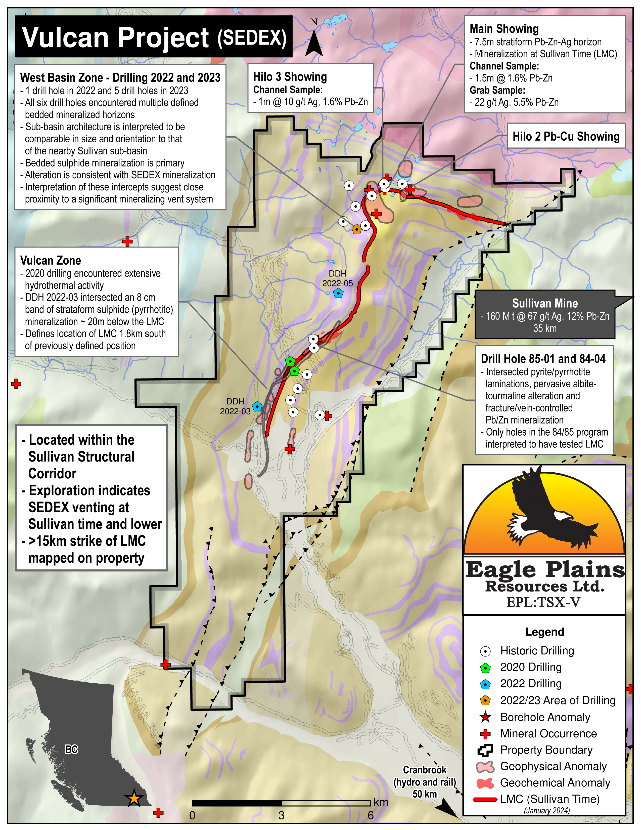
Historically there have been two main areas of interest on the Vulcan Project. The West Basin Zone which contains geological features similar to those seen within the Sullivan Mine itself and associated with the adjacent Sullivan-North Star Corridor. This zone contains the Main Showing where strata controlled pyrrhotite-galena-sphalerite occurs at the "Sullivan Horizon" over a 7.5 m thick interval . The Vulcan Zone is located approximately 5 km southwest of the West Basin Zone where surface geochemistry and diamond drilling efforts have been directed toward exploring the LMC sequence.
Eagle Plains Exploration
Eagle Plains acquired the property in 2002. Exploration highlights include:
- Reinterpretation of the historical geophysical data revealed corrupted elevation data in the original flight profiles. A new interpretation was produced using the corrected elevation data.
- Additional high-resolution airborne VTEM defined an anomaly that corresponds with rocks below the LMC, representing an untested target between two known mineral occurrences.
- A gravity survey identified possible discordant structures associated with the Hilo 3 showing, possibly representing a mineralized structure associated with Proterozoic growth faults that has not been detected at surface. Drill testing is recommended.
- Soil geochemical sampling across the LMC east of the West Basin and at the Vulcan Zone in the southern part of the property identified anomalous areas with multi-element Sullivan-type geochemical signature. Geologic mapping resulted in refining the position of the LMC to the west, suggesting that historic drilling in the area did not test the down-dip potential of the fertile stratigraphic horizon.
- I.P. and MT geophysics in the Vulcan Zone identified anomalies consistent with the Sullivan Type deposit model at the reinterpreted position of the LMC. A 2km geochemical anomaly is also located along the LMC coincident with multiple historic geophysical anomalies
- In 2020, one hole of a 2-hole drill program intersected significant hydrothermal alteration within the “exhalite interval” located beneath the Sullivan horizon, suggesting proximity to a hydrothermal source and potential SEDEX-style mineralization
- In early 2022, a modern airborne geophysical survey was flown to evaluate the southern portion of the property covering 8km of the prospective Sullivan horizon
Vulcan Drill Program 2022
In the Autumn of 2022 Eagle Plains self-funded a 3-hole diamond drill program designed to test the well-developed targets in central/northern portion of the property.
- The first hole of the program intersected an 8cm band of strataform sulphide (pyrrhotite) mineralization approximately 20m below the Lower Middle Contact (“LMC”) in rocks of the Aldridge Formation.
- The second hole and most northerly of the program yielded the most significant results yet encountered on the property. This hole targeted a down-hole geophysical anomaly located down-dip of a bedded sphalerite in a historical intercept at the LMC. This hole was deepened following observation of banded, cm-scale strata-controlled sphalerite and galena mineralization within a thick (139m) fragmental unit containing abundant clasts of sphalerite, galena and pyrrhotite mineralization persisting well below the interpreted Sullivan time horizon, which was intersected at 303m. XRF analysis of these cm-scale sphalerite bands indicated point concentrations in excess of 10% zinc in addition to highly anomalous silver, lead and cadmium values, among others. Similar mineralization is reported in historical drill holes near the North Star deposit approximately 2km south of the Sullivan, indicating proximity to an active feeder system which had apparently disrupted primary bedded sulphide mineralization. A downhole geophysical survey suggests discrete off-hole anomalies at depths consistent with mineralization observed in drill-core. Click here to view pictures of select intervals of this drill core
- The third hole of the program crossed the interpreted LMC at approximately 327m, and intercepted fragmental material and trace bedded sulphide mineralization, though thicknesses and mineralization is less persistent and intense than that seen in Hole 2 (VU22004). Disseminated sphalerite with associated tourmalinite was reported in a 1.2m wide vein intersected at 295m. Downhole geophysics was prevented due to near-surface caving within the hole.
Future Work
The Vulcan property warrants further work, with the focus on:
- Reinterpretation and modelling of historic drill data from the Hilo and West Basin areas to determine if previous drilling tested the mineralized horizon encountered in hole VU2022-04
- Modelling of the post 2022 drilling down-hole geophysical survey data
Eagle Plains - A Project Generator
Eagle Plains Resources is a project generator with several mineral exploration properties of merit that meet qualifying transaction requirements. We facilitate the listing process for capital pool companies and initial public offerings while providing technical expertise for exploration programs. Companies interested in co-operatively exploring any of our projects please contact: Chuck Downie at ccd@eagleplains.com or Andrew Wilson at abw@eagleplains.com or call 1 866 Hunt Ore (486 8673).
Details
The 12,044 ha Vulcan Property is located in the Purcell Mountains, 35 km NW of the historic Sullivan Mine at Kimberley, B.C. The Sullivan contained 160 million tons grading 12% Pb-Zn and 67 g/t Ag, with a mineable lifetime of 92 years, and a contained metal value in present dollars exceeding 35 billion dollars.
The Vulcan claims were acquired to cover four strata-bound Pb-Zn and Cu occurrences, hosted in Aldridge Formation and holds the potential to host significant sedimentary-exhalative (“SEDEX”) mineralization.
The property is easily accessible by a series of all-weather, logging and mining exploration roads and is 100% owned by Eagle Plains with no underlying royalties or encumbrances.
Project Highlights
- Overlies world-class Sullivan deposit stratigraphy
- Numerous Sullivan-type SEDEX mineralized occurrences and alteration
- Encouraging exploration to date with comprehensive database
- Located within the Sullivan Corridor – 35 km west of the Sullivan Mine
- Road accessible with nearby rail, highway, airport, smelter, hydro
Geology
The Vulcan property geology is contains many geologic features similar to those seen within the Sullivan Mine itself, and associated with adjacent Sullivan-North Star Corridor. These features are summarized below:
a) A stratigraphic sequence which is directly correlative with the Sullivan Deposit. This includes Lower Aldridge rocks (rhythmic succession of laminated to thin bedded fine grained wacke (argillite) and quartzitic wacke (argillaceous quartzite)) in contact with the overlying Middle Aldridge rocks (medium to thick bedded light grey weathering quartzitic wacke turbidites consisting of medium grained massive quartz-rich bases overlain by thin wacke-subwacke (argillite) tops), with an intraformational conglomerate and strata-controlled mineralization. This sequence has been mapped on the property over a 3 km strike length, and in thickness to 250 m.
b) Alteration including tourmalinization and albitization are present and in association with the Lower Middle Aldridge Contact (LMC).
c) Stratiform lead-zinc-silver mineralization has been noted in drillholes and on surface, and is stratigraphically located within the "Sullivan -Time" horizon. Sampling from the Main showing has returned values of 1.6% combined Pb/Zn over 1.5 m within a weakly mineralized section 7.5 m thick.
Animation of a SEDEX Deposit Forming
History
Originally staked by Cominco in 1957, exploration in the western portion of the property discovered Pb-Zn showings and widespread tourmaline mineralization, both recognized as being stratigraphic-controlled. A strong similarity between the Vulcan and the Sullivan Mine was documented by Cominco at this time noting that Pb-Zn-Ag mineralization "occur(s) in the same type of rocks, at the same point in the stratigraphic succession (LMC) and as the same type of mineralization" as at Sullivan. Deep drilling was recommended but deferred.
Regional stratigraphic correlation studies in the 70s confirmed that the Vulcan mineralization occurs at the LMC and suggested that the Sullivan type setting defined by the 1958 work was unique, and appeared to be localized in the western part of the Vulcan claims.
In 1979, Cominco again staked the Vulcan Claims. An access road was constructed and a single 188 m drill hole tested the LMC returning 1.1 m @ 0.35% Pb, 0.30% Zn mineralization located in the Lower Aldridge Formation.
In 1983/84, Cominco completed ground-based geophysics and geochemical surveys in the West Basin Zone. Work in this area was discontinued following these surveys and subsequent Cominco work 1984/85 was designed to locate and evaluate the LMC on the more accessible ground in the southern portion of the property. Mapping, soil geochemistry and geophysical surveys were completed which defined Pb-Zn and geophysical anomalies along the projection of the LMC in the southwestern portion of the property. The best geophysical anomalies interpreted to be at the LMC were targeted by five drill holes which with the exception of one were entirely within the Lower Aldridge and did not in fact test the LMC.
In 1991 a 5 hole - 1003 m drilling tested 2.6 km of the inferred LMC in the West Basin Zone, down dip and along strike of the Main Showing, for a Sullivan type sedex deposit. Channel sampling of the Main Showing returned values to 1.5m @ 1.6% Pb/Zn.
In 1992, further drilling tested the LMC in the West Basin Zone. The drilling located Sullivan-type stratigraphy and alteration in all holes but significant base-metal mineralization was not encountered. The down-dip extension of the LMC targeted by the 1991/92 drill holes remains untested.
In 2011, Fjordland Exploration identifying two coincident Pb-Zn anomalies in the Vulcan Zone along 1.8 km of the inferred LMC near one of the 1984 Cominco drill holes.
Vulcan Project Zones
Main Showing Area
At the Vulcan, the styles of mineralization, host rocks and alteration all show strong similarities to the Sullivan Deposit. To date, the best sulfide mineralization is exposed at the Main Showing. Strata controlled pyrrhotite-galena-sphalerite occurs at the LMC (Sullivan Horizon) in a 7.5 m thick zone. Here a 1.5 m channel sample graded 1.6% combined Pb-Zn and grab samples assayed up to 5.5% Pb-Zn and 22 g/t Ag.
West Basin Zone
The West Basin Zone area contains features similar to those seen within the Sullivan Mine itself and associated with the adjacent Sullivan-North Star Corridor. These include fragmentals and strata-controlled mineralization at Sullivan time, and extensive albite and tourmaline alteration.
Vulcan Zone
The Vulcan Zone area contains a 2 km long soil geochemical anomaly which is coincident with the interpreted southern extension of the LMC. Albite and tourmaline alteration similar to that observed within the Sullivan-North Star Corridor was also observed in one drill hole from this zone.
Eagle Plains Exploration
Eagle Plains staked the property in 2002.
2005 work included reinterpretation of data collected during a 1996 BC government funded high-resolution geophysical survey and integration into a GIS database. It was found that the GPS height and the barometric altimeter height used in the original survey interpretation was incorrect, rendering the original geophysical program highly suspect, if not worthless. A new interpretation was produced using the corrected elevation data.
In 2006, a high-resolution VTEM airborne geophysical survey defined a number of anomalies. The most interesting feature roughly traces the contact between Lower and Middle Aldridge rocks in the SW part of the property. The anomaly appears to correspond with rocks located stratigraphically below the LMC and represents a new, untested target between two known mineral occurrences at surface.
In 2011, an airborne gravity geophysical survey successfully identified possible discordant structures spatially associated with the Hilo 2 mineralized showing. The anomaly potentially represents a mineralized structure associated with Proterozoic growth faults that has not been detected at surface.
In 2012, geochemical sampling and geological evaluation of the Hilo 3 showing was carried out. A channel sample from the Hilo 3 returned 10.6 g/t Ag, 0.9% Pb and 0.7% Zn over the 1.0 m interval.
The 2014 soil geochemical program across the trace of the LMC in the northeastern part of the property was conducted. Results were encouraging, with a multi- element Sullivan type geochemical anomaly being defined.
The 2016 program consisted of data compilation, soil geochemical sampling, geophysical surveys and geologic mapping across the trace of the LMC in the Vulcan Zone to verify and expand upon a previous program carried out by Fjiordland Exploration. A Pb/Zn geochemical anomaly coincident with the Vulcan Showing was identified which is open to the north and defined over a strike length of 2 km. Geologic mapping resulted in refining the position of the LMC to the west, suggesting that historic drilling in the area did not test the down-dip potential of the fertile stratigraphic horizon.
2017 soil sampling further refined the 2016 results of relocating the position of the LMC.
2019 fieldwork included 2.8 line kms of I.P. and AMT geophysics in the Vulcan Zone which resulted in identifying anomalies consistent with the Sullivan Type deposit model. These anomalies are coincident with the reinterpreted position of the LMC, a 2km geochemical anomaly also located along the LMC and multiple historic geophysical anomalies. A multi-year area-based permit is currently active with diamond drilling recommended to test the down-dip potential for Sullivan-type mineralization along the reinterpreted location of the LMC in the Vulcan Zone.
A 2-hole, 977m diamond drill program in 2020 successfully intercepted significant hydrothermal alteration within the “exhalite interval” located beneath the Sullivan horizon, suggesting proximity to a hydrothermal source and potential SEDEX-style mineralization. Another hole tested a strong electromagnetic conductor and intersected a thick gabbroic intrusive containing a sequence of narrow graphitic seams, which were the likely source of a strong electromagnetic conductor.
In early 2022, a modern airborne geophysical survey was flown to evaluate the southern portion of the property covering 8km of the prospective Sullivan horizon.
Vulcan 2022 Drill Program
In the Autumn of 2022 Eagle Plains self-funded a 3-hole diamond drill program designed to test the Sullivan stratigraphy (LMC) and associated geophysical anomalies in central/northern portion of the property.
- The first hole of the program intersected an 8cm band of strataform sulphide (pyrrhotite) mineralization approximately 20m below the Lower Middle Contact (“LMC”) in rocks of the Aldridge Formation. Preliminary results obtained using a portable XRF spectrometer indicate elevated zinc values for the interval. Downhole geophysics was attempted but prevented due to near surface caving within the hole.
- The second hole was the most northerly of the three holes and yielded the most significant results yet encountered on the property. This hole targeted a down-hole geophysical anomaly located down-dip of bedded sphalerite intercepted at the Sullivan stratigraphy (LMC) in historic drilling. This hole intersected a thick 334-473m (139m) fragmental unit containing abundant clasts of sphalerite, galena and pyrrhotite mineralization overlaying a thick 473-597m (124m) intercept of bedded Aldridge with intermittent banded, cm-scale strata-controlled sphalerite (zinc) mineralization persisting well below the interpreted LMC time horizon, which was intersected at ~303m. Portable XRF analysis of these cm-scale sphalerite bands indicated point concentrations in excess of 10% zinc in addition to highly anomalous silver, lead and cadmium values, among others. Similar mineralization is reported in historical drill holes near the North Star deposit approximately 2km south of the Sullivan, indicating proximity to an active feeder system which is apparently disrupting primary bedded sulphide mineralization (P. Ransom, P.Geo., personal communication). A downhole geophysical survey was successfully completed, and suggests discrete off-hole anomalies at depths consistent with mineralization observed in drill-core. Click here to view pictures of select intervals of this drill core
- The third hole of the program crossed the interpreted LMC at approximately 327m, and intercepted fragmental material and trace bedded sulphide mineralization, though thicknesses and mineralization is less persistent and intense than that seen in Hole 2 (VU22004). Disseminated sphalerite with associated tourmalinite was reported in a 1.2m wide vein intersected at 295.0m. A downhole geophysical survey was attempted on this hole, but as was the case with Hole 1, near-surface caving within the hole prevented insertion of the downhole probe, resulting in abandonment of the survey in this area.
Future Work
The Vulcan property warrants further work, with the focus on:
- Reinterpretation and modelling of historic drill data from the Hilo and West Basin areas to determine if previous drilling tested the mineralized horizon encountered in hole VU2022-04
- Modelling of the post 2022 drilling down-hole geophysical survey data
Eagle Plains - A Project Generator
Eagle Plains Resources is a project generator with several mineral exploration properties of merit that meet qualifying transaction requirements. We facilitate the listing process for capital pool companies and initial public offerings while providing technical expertise for exploration programs. Companies interested in co-operatively exploring any of our projects please contact: Chuck Downie at ccd@eagleplains.com or Andrew Wilson at abw@eagleplains.com or call 1 866 Hunt Ore (486 8673).
Updated March 19, 2026

Eagle Plains Reviews 2023 Drilling Results at Vulcan, Engages Sinn for Communications and Marketing

Fieldwork Underway at Eagle Plains’ Findlay Critical Metals Project

Eagle Plains Completes Summer Drilling Program at Vulcan Critical Metals Project, Southeast BC

Eagle Plains Provides Update on Expanded Vulcan Drill Program, Announces Flow-through Financing
Photos