Dianne Lake Project
The 1,872ha Dianne Lake Property is located 18 km NW of Uranium City in northern Saskatchewan. This Ag/Cu and U project is accessible via ski- or float-equipped fixed wing aircraft.
-
- Saskatchewan
-
- Available for option: Yes
-
- Copper,
- Silver,
- Uranium
Project Highlights
- Known mineralization is well-defined by structural intersections which are repeated throughout the property and underexplored
- Excellent geology favourable for high-grade Ag/Cu/Co deposits
- Potential for unconformity-style basement-hosted uranium mineralization
- Encouraging exploration to date including mineralized drill intercepts
- Multiple untested geophysical anomalies associated with favourable geology
Summary
The 1,872ha Dianne Lake Property is located 18 km NW of Uranium City in northern Saskatchewan. This Ag/Cu and U project is accessible via ski- or float-equipped fixed wing aircraft.
Project Highlights
- Known mineralization is well-defined by structural intersections which are repeated throughout the property and underexplored
- Excellent geology favourable for high-grade Ag/Cu/Co deposits
- Potential for unconformity-style basement-hosted uranium mineralization
- Encouraging exploration to date including mineralized drill intercepts
- Multiple untested geophysical anomalies associated with favourable geology
The Dianne Lake property lies within the Rae Province of the Precambrian Shield where it is composed of cratonic blocks, mainly consisting of Archean rocks, generally bounded by mylonitic shear zones and intervening terrains of reworked and remobilised Archean and/or Early Proterozoic rocks. The property is located within the Zemlak Domain near its eastern NE-trending fault-bounded boundary (Black Bay) with the Beaverlodge Domain.
History
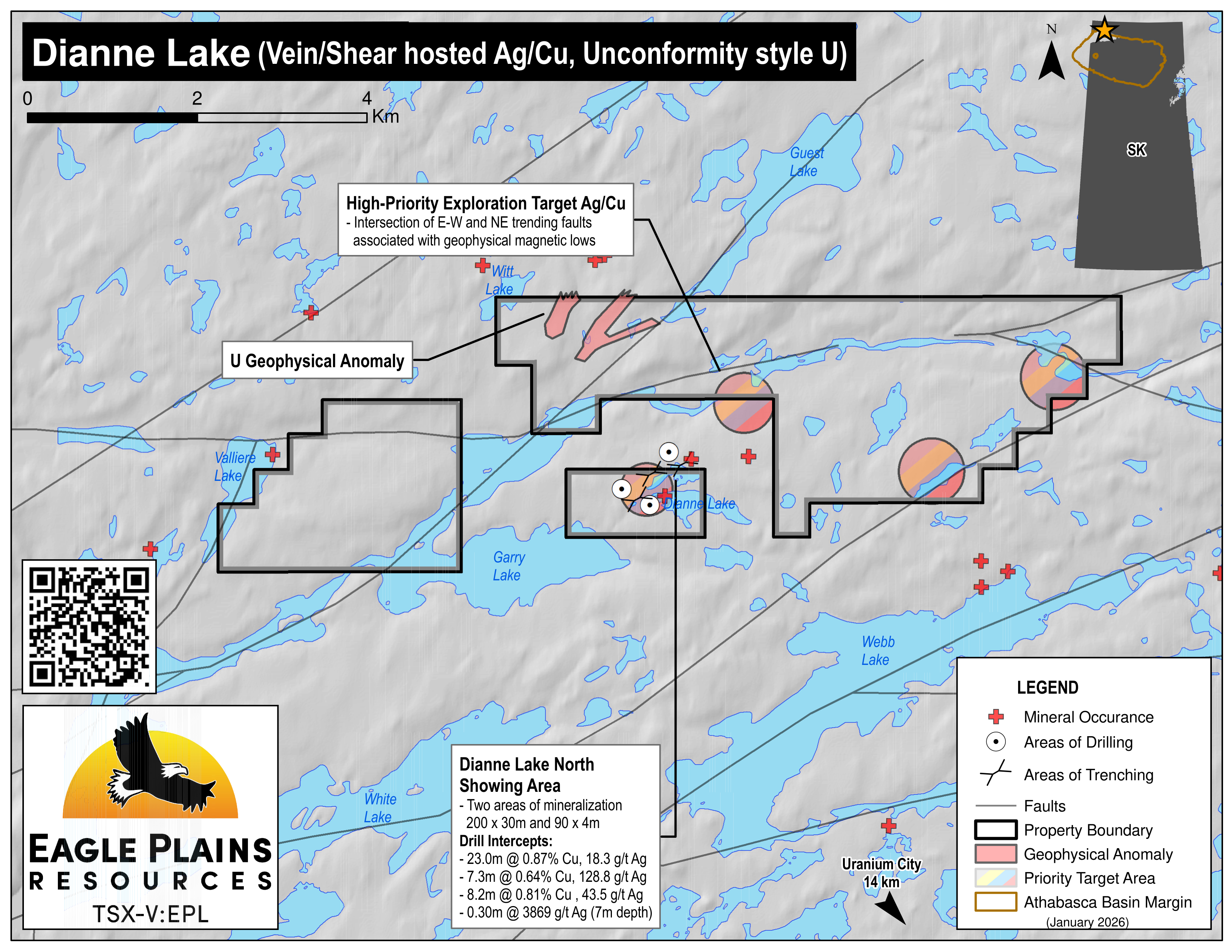
The property has undergone government and industry exploration between the 1950’s to the early 2000’s. This included detailed geological mapping, airborne geophysical surveys, lake sediment sampling and economic mineralization studies by government. Early industry exploration focussed on uranium with prospecting, radiometric surveys and trenching. In 1967, copper-silver mineralization was discovered followed by prospecting, geological mapping, ground-based geophysical surveying and soil sampling outlining an area of extensive and locally high-grade copper-silver mineralization NE of Doug Lake. IP surveys were found to be very effective in identifying mineralized outcrop. In the late 60’s, 52 drill holes (~7000m) were completed with intercepts including 23m of 0.87% Cu / 18.3 g/t Ag and 30cm of 3869 g/t Ag. Further work continued with Airborne EM and magnetic surveys, ground VLF-EM surveys, geological mapping and resampling of historic core. A final work program of geophysical surveying, ground prospecting and trenching was conducted in the late 90’s and located new mineralized areas 800 meters NE of the Dianne Lake showing.
Eagle Plains Exploration
In 2022, a high-resolution helicopter-borne magnetic and radiometric survey over the project area revealed higher responses in the west associated with unconformably overlying metasedimentary units while E and NE-trending magnetic breaks outline steeply dipping contacts/faults representing potential mineralizing plumbing systems.
Future Work
Modelling of the geophysics in relation to known showings has generated 4 new priority targets for follow up fieldwork: 3 Ag-Cu-Co targets and one uranium target. Compilation of historical work is underway to generate drill targets along trend of the high-grade Ag-Cu-Co showings.
Eagle Plains - A Project Generator
Eagle Plains Resources is a project generator with several mineral exploration properties of merit that meet qualifying transaction requirements. We facilitate the listing process for capital pool companies and initial public offerings while providing technical expertise for exploration programs. Companies interested in co-operatively exploring any of our projects please contact: Chuck Downie at ccd@eagleplains.com or Andrew Wilson at abw@eagleplains.com or call 1 866 Hunt Ore (486 8673).
Details
The 1,872ha Dianne Lake Property is located in northern Saskatchewan approximately 18 km northwest of Uranium City. The property is accessible year-round from Uranium City via ski- or float-equipped fixed wing aircraft.
The property was staked in 2020 to incorporate 3 significant silver-copper endowed mineral showings and associated east-west and north-east trending structures.
The project is 100% owned by Eagle Plains with a 2% NSR held by Eagle Royalties containing a 1% buy-back clause.
Project Highlights
- Known mineralization is well-defined by structural intersections which are repeated throughout the property and underexplored
- Excellent geology favourable for high-grade Ag/Cu/Co deposits
- Potential for unconformity-style basement-hosted uranium mineralization
- Encouraging exploration to date including mineralized drill intercepts
- Multiple untested geophysical anomalies associated with favourable geology
Geology
The Dianne Lake property lies within the Rae Province of the Precambrian Shield where it is composed of cratonic blocks, mainly consisting of Archean rocks, generally bounded by mylonitic shear zones and intervening terrains of reworked and remobilised Archean and/or Early Proterozoic rocks. The property is located within the Zemlak Domain near its eastern NE-trending fault-bounded boundary (Black Bay) with the Beaverlodge Domain. Further north, the Zemlak Domain is separated from the reworked Nolan Block by the east-trending Tarzin River Fault
The majority of the tenured area is underlain by the White Lake Granite, a whitish-grey, granite-granodiorite complex of largely anatectic origin. The remainder of the claim is underlain by quartz-feldspar gneiss, banded and partly migmatitic, with generally less than 15 percent mafic minerals.
Immediately west of the tenured area, high grade facies rocks of the White Lake Granite are unconformably overlain by the basinal Thluicho Lake Group. This Group comprises a greenschist facies siliciclastic fining-upward succession comprising a basal polymictic conglomerate grading upwards into arkoses and argillites (Scott, 1988). Cu-Pb-Ag±U deposits and showings, some with anomalous values of Co, Ni, Zn, Au, and As, have been known for some time in the region. The mineralization occurs at, or slightly below, the Thluicho Lake Group–basement contact and was not recognized where the sedimentary succession and unconformity have been removed by erosion. Government mapping has recognized a small flat lying outlier of Thluicho Lake rocks near the northern property boundary, attesting to a property wide proximity to this flat lying unconformity.
Major lineaments of the area trend parallel to lithology breaks. Analysis of fracture azimuths shows three dominant strike trends and Ag-Co-Ni mineralization appears related to two of these fracture sets. Some of the largest east trending structures are exploited by diabase dykes which have spatial association to mineralization at the property scale. These spatial relationships may indicate that the mineralization formed due to redox reactions at the Thluicho unconformity that were locally facilitated by heat from the diabase dykes.
History
Government Surveys
Broad-scale surveys completed by the Geological Survey of Canada and the Saskatchewan Geological Survey included geological mapping of the Black Bay area in 1954, a directed study of assemblages east of Thluicho Lake in 1978 and detailed geological mapping and economic mineralization studies of the area in the 1980’s.
In the early 2000’s a series of mapping studies were completed in the greater region as part of the Uranium City project. A multi-parameter airborne geophysical survey was completed over the region in 2001. In 2011, the GSC in conjunction with the Sask Geological survey completed regional airborne magnetic and radiometric surveys as part of the Northwestern Athabasca Basin project. A number of GSC lake sediment surveys were also completed in the region.
Industry Exploration
Industry exploration within the Dianne Lake tenure spans the years of 1955-2000. The earliest work in the 1950’s focussed on uranium potential in the Witt and Webb lake areas, with limited prospecting, radiometric surveys and trenching. While searching for uranium, copper-silver mineralization was discovered by Consolidated Skeena Mines in 1967. The following year they completed ground geological mapping, prospecting, ground geophysical surveys and soil sampling which outlined an area NE of Doug Lake of extensive, and locally high-grade copper-silver mineralization. IP surveys were found to be very effective in identifying mineralized outcrop.
Between 1968-1979 various operators assessed the copper-silver potential which included 52 drill holes (~7000m) in the late 1960’s. Intercepts included:
| Drill Hole # | Mineralized Intercept | Grade |
|---|---|---|
| DDH 1968-25 | 23.0m | 0.87% Cu and 18.3 g/t Ag |
| DDH 1968-04 | 7.3m | 0.64% Cu and 128.8 g/t Ag |
| DDH 1968-15 | 8.2m | 0.81% Cu and 43.5 g/t Ag |
| DDH 1969M1 | 0.30m at a depth of 7m | 3869 g/t Ag |
Work continued in the 1980's with SMDC and Comaplex carrying out Airborne EM and magnetic surveys, ground VLF-EM surveys, geological mapping and resampling of historic core. The last significant ground work was conducted by Consolidated Pine Channel Gold in 1998 who completed geophysical surveying, ground prospecting and trenching which located new mineralized areas 800 meters northeast of the Dianne Lake showing. The last recorded work on the property was a 1999 Geotem airborne EM and magnetic geophysical survey.
Eagle Plains Exploration
In 2022, Eagle Plains conducted a high-resolution helicopter-borne magnetic and radiometric survey over the Dianne Lake Project area. Results from the airborne magnetic survey reveal a general west to east decrease in relative magnetic intensity. Higher magnetic responses are, in part, associated with the unconformably overlying Thluicho Lake Group metasedimentary units near the western property boundary, while east and northeast-trending magnetic breaks outline steeply dipping basement lithological breaks and potential mineralizing plumbing systems.
Future Work
The purpose of the geophysical survey was to provide a better baseline geophysical dataset in order to define/correlate geophysical signatures to known mineralized showings, and to use those associations as targets for exploration in other areas of the property. Modelling of the geophysics in relation to known showings has generated 4 new priority targets for followup fieldwork: 3 Ag-Cu-Co targets and one uranium target. Future work will include targeted prospecting for these commodities, and updated property-scale geological mapping to better define prospective structural elements, including additional Thluico Lake Group outliers, diabase dykes and shear systems. Detailed study and compilation of the historical workings is also underway to generate followup drill targets along trend of the high grade Ag-Cu-Co showings.
Eagle Plains - A Project Generator
Eagle Plains Resources is a project generator with mineral exploration properties of merit that meet qualifying transaction requirements. The Burbidge Lake Property, while not a project of merit, is available for option to joint-venture partners. We facilitate the listing process for capital pool companies and initial public offerings while providing technical expertise for exploration programs. Companies interested in co-operatively exploring any of these projects please contact: Chuck Downie at ccd@eagleplains.com or Mike Labach at Andrew Wilson at abw@eagleplains.com or call 1 866 Hunt Ore (486 8673).
Updated March 19, 2026

Eagle Plains Increases Saskatchewan Uranium Portfolio to 40,050 Hectares