
Pine Channel Project
The Pine Channel Property consists of 32 mineral dispositions covering 8,630 hectares located approximately 40 km west of Stony Rapids, Saskatchewan which is the logistics/business hub for northern Saskatchewan. The property can be accessed year-round by float- or ski-equipped aircraft from Stony Rapids or Fort McMurray, AB. The eastern and northern part of the property is transected by a high voltage powerline. Most geological fieldwork is limited to late May to October but other operations such as geophysical surveys and diamond drilling can be completed year-round.
-
- Saskatchewan
-
- Available for option: Yes
-
- Gold,
- Silver,
- Nickel,
- Copper,
- Uranium
Project Highlights
- Prior to acquisition it has not been explored since 1988
- Multiple encounters of high-grade gold in drill intercepts
- Numerous mineralized gold occurrences
- Encouraging exploration to date with most drilling <100m
- Hydro powerline bisecting the property
Summary
The Pine Channel Property consists of 32 mineral dispositions covering 8,630 hectares located approximately 40 km west of Stony Rapids, Saskatchewan which is the logistics/business hub for northern Saskatchewan. The property can be accessed year-round by float- or ski-equipped aircraft from Stony Rapids or Fort McMurray, AB. The eastern and northern part of the property is transected by a high voltage powerline. Most geological fieldwork is limited to late May to October but other operations such as geophysical surveys and diamond drilling can be completed year-round.
Project Highlights
Highlights from documented historical work and previously reported results include:
- Algold Bay: 63.5 g/t Au over 0.6 m (drill hole) (SMDI 1575)
- North Norite Bay: 407.96 g/t Au over 0.5 m (drill hole) (SMDI 2183)
- ELA: 25.8 g/t Au over 0.51 m (drill hole) (SMDI 1574)
- Holes G-1 and G-3: 3.20 g/t Au over 1 m (drill hole) (SMDI 2329)
- Occurrence No. 6/Occurrence No. 8: 90.6 g/t Au over 0.2 m (trench sample) (SMDI 1581)
- Cole Lake Ni-Cu: 0.45% Ni over 7.0 m (drill hole), 6.2 g/t Au, 0.01% Ni and 0.06% Cu over 3.0 m (trench sample) (SMDI 1583)
- Multiple untested geophysical anomalies and mineralized trends associated with favourable geology
The main deposit type that is being explored for at Pine Channel is structurally controlled vein-quartz (lode) gold deposits. Mineral occurrences on the Pine Channel Property contain predominantly gold, with rare base metal occurrences. Within the Pine Channel tenures there are twenty documented historical showings.
Government mapping in the Pine Channel area dates from 1913, with the first industry work reported in 1950. A total of 51 assessment reports have been filed within the current Pine Channel tenure area. Past operators include Golden Rule Resources Ltd. and Colchis Resources Ltd. who were both active on the project during the 1980’s, the last sustained period of exploration in the area. The most recent work prior to Eagle Plains acquiring the claims in 2018 was in 2013 when the area was flown with an airborne Variable Time Domain Electromagnetic (“VTEM”) survey focused on locating targets for diamond exploration. There has been a total of 6,066 metres of diamond drilling in 115 historic holes completed within the current Pine Channel property claim boundaries, with the majority of the holes completed less than 100 metres in length. Although the wide-spaced drilling did intersect significant gold mineralization in places, much of the drilling was completed using thin diameter core which is considered ineffective for assessing the high-grade “nuggety” gold shears and veins found at Pine Channel.
Eagle Plains Exploration
Since acquiring the property, Eagle Plains has completed field programs focused on prospecting and mapping in areas of known mineral occurrences. The work confirms the widespread occurrences of auriferous quartz veins and associated shear systems in the Pine Channel property. Analytical results from the seventy-two rock samples collected in 2020 ranged from 6 ppb Au to 68.4 g/t Au. Twenty-three of the samples returned greater than 1 g/t Au, and eight returned greater than 10 g/t Au. The most encouraging of the known showings are the ELA Shaft showing (SMDI 1574) and Occurrence No. 6 and No. 8 (SMDI 1581), which both demonstrate anomalous gold geochemical results and potential for extension of known mineralization along strike.
2022 and 2024 work included a helicopter-borne high-resolution aeromagnetic and radiometric survey and a high-resolution LiDAR and orthophoto survey. Lineation analyses of the LiDAR imaging, combined with the aeromagnetic data, defined a number of new target areas adjacent to and along strike from known mineralization.
2025 fieldwork by Eagle Plains focused on ground truthing of targets generated through lineation analyses. Of the 64 rock samples collected, six returned values greater than 10g/t Au with the highest sample returning 427 g/t from a grab sample at the Pit Occurrence. Interpretation of the results indicate that higher grades are associated with geophysical transition zones and complex structural corridors, with mineralization focused along secondary structures and/or splays and at zones of lineament intersection.
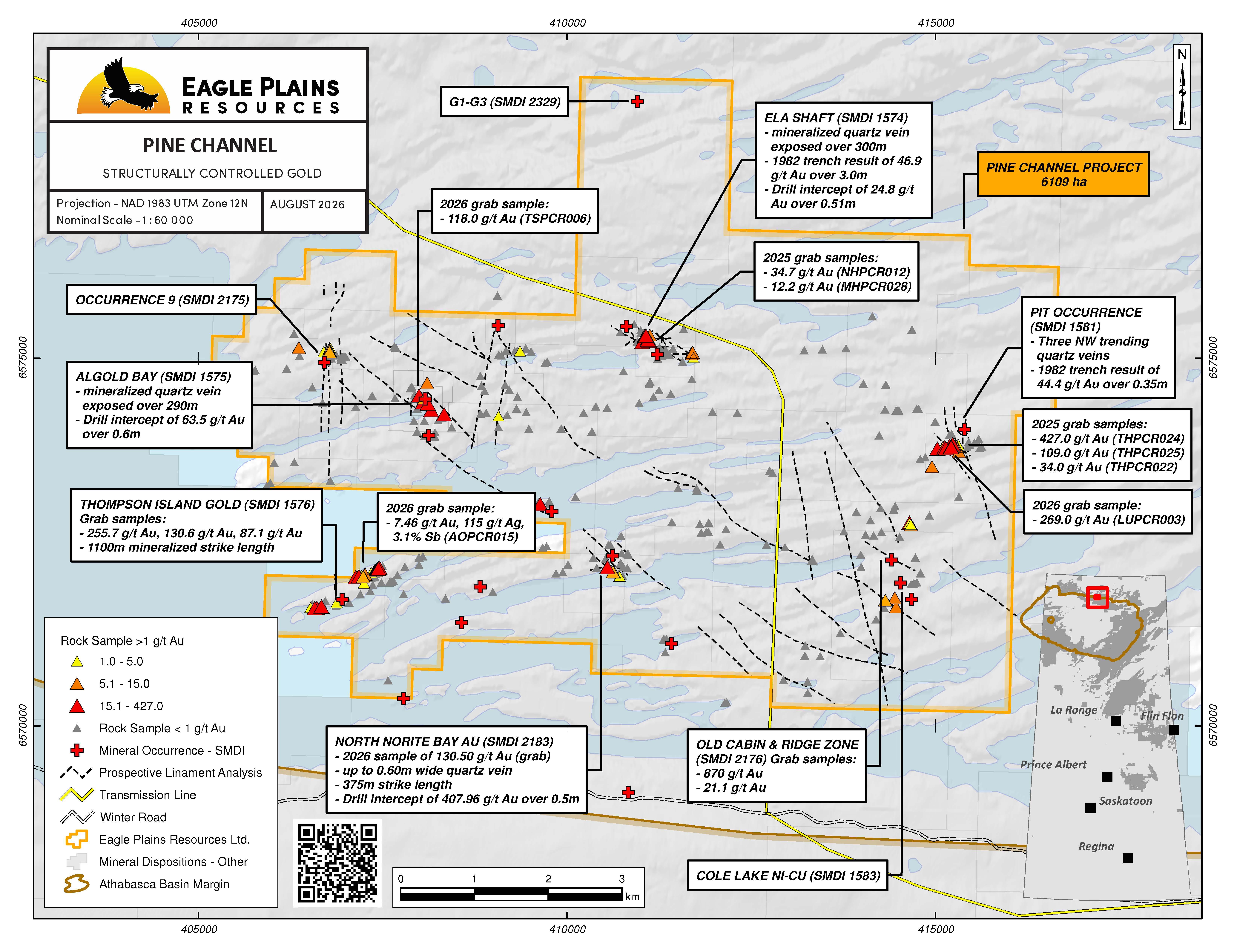
See Pine Channel 2026 Exploration Results Map
2026 Field Program
The purpose of the 2026 field program was to refine target areas identified by previous Eagle Plains work and data compilation, in order to define and prioritize diamond drill locations. Geology crews focused on determining structural controls on mineralization, confirmation sampling of high-grade gold mineralization reported from historical exploration on the property, and evaluating targets generated through airborne magnetic and LIDAR interpretation.
A total of 55 rock samples (54 grab samples, 1 chip sample) were collected in 2026. Analytical results ranged from trace values to a highest value of 269g/t Au (grab sample), with thirteen samples returning over 1 g/t Au, including 3 samples over 100 g/t Au. The program was managed by TerraLogic Exploration Inc. of Cranbrook, BC. The samples were analysed by ALS Canada Ltd. using fire assay (Au) and multi-element characterization.
Pit Occurrence and no. 10 showing Area (SMDI 1581, 2177)
The Pit target Area (SMDI 1581) comprises a series of 5 shear hosted quartz veins in a structurally complex setting favorable to form structural dilation zones. Historical results from trenching at the Vein 6 occurrence include 44.36g/t Au over 0.35m (AR 74O08-0054). 2026 resampling of mineralized quartz vein material from the Vein 3 trench returned 269.00 g/t Au (LUPCR003).
North Norite Bay (SMDI 2183)
The North Norite Bay (SMDI 2183) target area, exposed at surface over a strike length of 375m, consists of shear hosted quartz veins up to 0.60m in width. Historical chip sampling of trenches returned up to 11.81 g/t Au over 0.17m, with drill results including DDH GT88-11, which returned 407.96 g/t Au over 0.5m (AR 74O07-0076). In 2026, rock (grab) sample THPCR030, collected from quartz vein material from a historical trench, returned 130.50 g/t Au.
Algold Bay (SMDI 1575 & 1578)
2026 sampling at Algold Bay (SMDI 1575) confirmed the presence of high-grade gold mineralization reported in historical trenching and diamond drilling which defined shear hosted gold mineralization over a length of 290m, open in both directions along strike and to depth. Historical trench results include 11.8 g/t Au over 0.6m with drill results including DDH PC2-1 which returned 2.04 oz/ton (63.5/t) Au over 0.6m (SMAD 74O07-0057). 2026 sampling of the historical trenches include rock (grab) sample TSPCR006, which returned 118.0 g/t Au.
Occurrence 9 (SMDI 2175)
The Occurrence 9 target area is defined by three dominant mineralized quartz veins. The Main Vein is up to 2.5 m wide and has been exposed by historical workings over an approximately 200m strike length. The Rob and AC veins are cross cut by the Main Vein, and may represent faulted offsets of the same vein. Historic results rock (chip) samples include 4.3g/t Au over 2.0m (Main Vein), 1.05 g/t Au over 0.6m from the AC vein and 0.1g/t Au over 1.11m at the Rob vein (SMAD 74O07-0057). In 2026, AOPCR009, a rock (grab) sample of quartz vein material from a historical trench, returned 10.15 g/t Au.
Old Cabin and Ridge (SMDI 2176)
The Old Cabin & Ridge target area is comprised of multiple quartz and carbonate veins assessed at surface in historical trenching and at shallow depths by diamond drilling. At the Old Cabin occurrence, gold mineralization, including visible gold, is associated with arsenopyrite and pyrite with historical rock (grab) samples reporting up to 867.38 g/t Au (SMAD 74O07-0076). In 2026, further sampling of historical trenches confirmed gold mineralization associated with sulphide-bearing quartz veins. Rock (grab) samples NGPCR002, AOPCR013 and THPCR026 returned 3.25, 4.8, 5.65 g/t Au respectively.
Thompson Island Gold (SMDI 1576)
The Thompson Island Gold target area consists of nine gold-bearing quartz veins and mineralized shears defined over an approximately 1100m length. Historical exploration reports rock (grab) samples up to 255.7g/t Au. Historical drill results from DDH Z1-10 (SMAD 74O07-0045) include 1.2m at 7.46g/t Au. In 2026, rock (grab) sample AOPCR015, returned 7.46 g/t Au, 115 g/t Ag, 8.7% Pb and 3.1% Sb.
ELA & no.5 showings (SMDI 1574,2174)
The Ela Occurrence (SMDI 1574) is a NW-trending vein up to 4.0m in width, and exposed in a series of trenches over a strike length of 325m. Historical trench results include up to 46.9g/t Au over a 3.0 m chip sample. 1987 diamond drilling confirmed Au mineralization, reporting up to 25.8g/t Au over 0.51m at vertical depth of 25m (SMAD 74O07-0076). 2025 work by Eagle Plains assessed potential along-strike and off-axis from the main Ela Vein. MHPCR028, a grab sample collected 55m east of the main vein, along a probable parallel vein system, returned 12.2 g/t Au. A 2025 grab sample from an 80cm width exposure of the main Ela Vein returned 34.7 g/t Au (NHPCR012). In 2026, rock (grab) sample LUPCR002, collected from a quartz vein, subparallel to the main Ela structure, returned 0.99 g/t, highlighting the potential for mineralization in the hanging wall and footwall blocks of the main Ela Vein.
Rock grab samples are selective samples by nature and as such are not necessarily representative of the mineralization hosted across the property. Some of the above results were taken directly from the SMDI descriptions and assessment reports (SMAD) filed with the Saskatchewan government. Management cautions that historical results were collected and reported by past operators and have not been verified nor confirmed by a Qualified Person, but form a basis for ongoing work on the subject properties. Eagle Plains’ management cautions that past results or discoveries on proximate land are not necessarily indicative of the results that may be achieved on the subject properties.
Future Work
Comprehensive data interpretation and analyses is underway to define and prioritize targets for diamond drill testing.
Details
History
In the Pine Channel area, reconnaissance geology in the form of government reviews and mapping programs began in the late 1950’s. Several additional reports on uranium deposits and gold occurrences were carried out being carried out into modern times. In the late 80’s geological mapping at the 250k scale had been completed over the area. Additional government datasets include 3 airborne geophysical surveys and GSC lake sediment geochemistry.
Industry exploration of the area began in 1950 and a total of 41 work programs have been conducted within the property. These include 20 drill holes, prospecting, trenching, mapping and geophysics by Goldfields Uranium Mines from 1950-1952. Between 1955 and 1988 the property has been investigated by a number of companies including but not limited to Cominco, Denison, SMDC, Colchis Resources, Minatco, Inexco, Varmac Uranium and Western Mines. These companies preformed 36 programs on the property including 106 holes over 11 drill programs, 17 geophysical surveys of various types and size, trenching, geologic mapping, prospecting, soil and rock sampling, biogeochemical and sediment sampling.
The last exploration program to be carried out on the property was in 1988 and the majority of the drilling to that point was completed using small diameter (AX) core. This small core is poorly suited to sampling the high grade, nuggety gold mineralization present in the Pine Channel area and that the historically low gold grades that drilling returned relative to gold grades observed at surface are likely not accurate. In addition to this, most of the drilling on the property has been relatively shallow (~<100 m) and the potential to test for further continuity at depth is considered to be excellent.
The main deposit type that is being explored for at Pine Channel is structurally controlled vein-quartz (lode) gold deposits. Mineral occurrences on the Pine Channel Property contain predominantly gold, with rare base metal occurrences. Within the Pine Channel tenures there are twenty documented historical showings.
Government mapping in the Pine Channel area dates from 1913, with the first industry work reported in 1950. A total of 51 assessment reports have been filed within the current Pine Channel tenure area. Past operators include Golden Rule Resources Ltd. and Colchis Resources Ltd. who were both active on the project during the 1980’s, the last sustained period of exploration in the area. The most recent work prior to Eagle Plains acquiring the claims in 2018 was in 2013 when the area was flown with an airborne Variable Time Domain Electromagnetic (“VTEM”) survey focused on locating targets for diamond exploration. There has been a total of 6,066 metres of diamond drilling in 115 historic holes completed within the current Pine Channel property claim boundaries, with the majority of the holes completed less than 100 metres in length. Although the wide-spaced drilling did intersect significant gold mineralization in places, much of the drilling was completed using thin diameter core which is considered ineffective for assessing the high-grade “nuggety” gold shears and veins found at Pine Channel.
Geology
The Pine Channel project lies within the Tantato Domain composed of highly deformed mylonitic gneisses forming the eastern margin of the Archean Rae Craton. The lithologies within the domain are predominantly supracrustal and appear to be derived from volcaniclastics manifest as felsic to mafelsic granulites and gneisses. The supracrustals of the Tantato Domain were later intruded by granitoid bodies.
Numerous gold occurrences have been discovered within the property boundary which is located along the SW portion of the Tantato structure. This area is host to a structurally lower sequence of mylonitic garnet-quartzofeldspathic gneisses and mylonitic garnet-clinopyroxene mafic gneisses. The garnet-quartzo-feldspathic gneisses are strongly differentiated between discontinuous quartz lenses alternating with feldspar layers. The garnet-clinopyroxene gneisses have variously been referred to as norites, and meta-basites that are most likely derived from extrusive and intrusive igneous rocks. These mafic gneisses are host to concordant zones of pyrrhotite and pyrite mineralization and locally are associated with graphitic schists. The rocks have been subject to polyphase metamorphism with the dominant foliation trending to the northeast and rocks typically dipping between 40°-60° to the southeast.
Mineral Occurrences
There are 32 mineral occurrences on the Pine Channel Property, the majority of which are interpreted to host structurally-controlled mesothermal lode gold mineralization. Nickel and uranium are also present on the property and appear to be structurally controlled in polymetallic veins and intrusion-hosted magmatic.
Some of the more notable of these showings include:
ELA Au Showing
The ELA Au showing is a quartz vein mineralized with arsenopyrite, pyrite, and minor chalcopyrite disseminations. The vein varies between 1-4m wide, a strike length of 240m and 60m deep, open on both ends and to depth. Drilling assays reported from 0.31 g/t Au over 0.7 m to 35.96 g/t Au over 0.55 m. A size estimate of an ore shoot within the vein system was released in 1952 and recalculated again 1982 suggesting a high-grade shoot of 36.6 m long, 1.2 m wide and 60 m deep with a grade of 15.81 g/t Au. The 1982 estimate calculated it to be 17.0 m long and 2.1 m wide with an uncut grade of 29.45 g/t Au. Later work traced the vein for 240 m and in 1987, 12 NQ drill holes traced the mineralized vein to 38m deep, highlights from these programs include:
| Sample Type | Results | Description of Zone and Sampling |
|---|---|---|
| Drill Intercept | 0.55m @ 39.96 g/t Au |
ELA Au Showing, 1-4m wide, 240m strike |
| Drill Intercept | 0.52m @ 45.26 g/t Au | |
| Drill Intercept | 1.75m @ 5.27 g/t Au | |
| Trench | 7.6m @6.82 g/t Au, 8.68 g/t Ag | |
| Trench | 3.0m @ 24.52 g/t Au |
Algold Bay Zone Au Showings
The Algold Bay Zone covers several Au mineralized showings on the north shore of Lake Athabasca. Gold mineralization at Algold Bay was first reported in 1935 and subsequent work has included prospecting, trenching, geophysical surveys, and 5 short diamond drill holes, with the last recorded work in 1988 by Colchis Resources. The MEL-CEC showing is a NW striking, vertically-dipping shear zone exposed for approximately 300m strike length. The Algold Creek occurrence is a massive quartz-tourmaline vein 3.7m in width while the Occurrence 3 Au Showing is comprised of quartz stringers with arsenopyrite and visible gold. Exploration highlights from these showings include:
| Sample Type | Results | Description of Zone and Sampling |
|---|---|---|
| Drill Intercept | 0.6m @ 63.5 g/t Au | MEL-CEC |
| Chip Sample | 0.8m @ 100.1 g/t Au and 1.9m @ 26.4 g/t Au |
MEL-CEC |
| Grab Sample | 9 g/t Au | Algold Creek |
| Grab Sample | 5.7 g/t Au | Occurrence #3 |
PIT Claim Adit - Occurrences #6 and #8
These showings collectively known as the PIT Claim Adit are located 150m to 200m apart. Occurrence #6 Au consists of 5 veins. Veins 1-3 host hosting tourmaline, arsenopyrite and pyrite mineralization while veins 4 & 5 host to considerable arsenopyrite, minor pyrite and may or may not contain quartz. Located to the west, Occurrence #8 Au is a 60m long 0.03-0.3 m wide quartz vein hosted within garnet-quartz-feldspar paragneiss. The vein is mineralized with arsenopyrite and rare specks of native copper.
| Sample Type | Results | Description of Zone and Sampling |
|---|---|---|
| Trench | 0.35m @ 44.36 g/t Au and 32.55 g/t Ag | Occurrence #6 West |
| Trench | 0.2m @ 5.18 g/t Au and 0.45m @ 3.78 g/t Au | Occurrence #6 East Vein |
| Trench | 0.2m @ 90.6 g/t Au | Occurrence #8 |
| Trench | 0.3m @ 3.32 g/t Au and 0.71 g/t Ag | Occurrence #8 |
Cole Lake Ni-Cu Occurrence
The Cole Lake Occurrence is a nickeliferous pyrrhotite zone occurring within a 12.1m wide norite body. The norite body is underlain by paragneisses and has been traced for 183m on strike. Pyrrhotite is disseminated throughout the norite and also concentrated in a ~1.0 m wide gossanous fractured central portion of the norite. Four drill holes and chip sampling from trenches were conducted with the following highlights:
| Sample Type | Results | Description of Zone and Sampling |
|---|---|---|
| Drill intercept | 0.45% Ni over 7.0 m | Cole Lake Ni-Cu - drill hole #1 |
| Drill intercept | 0.40% Ni over 11.3 m | Cole Lake Ni-Cu - drill hole #2 |
| Drill intercept | 0.65% Ni over 4.6 m | Cole Lake Ni-Cu - drill hole #4 |
| Trench | 0.97% Ni and 0.13% Cu over 2.3 m | Cole Lake Ni-Cu |
North Norite Bay Au Showing
This showing is a quartz filled shear zone with veins up to 0.6 m wide and traced over a strike length of 375m in biotite-quartz-feldspar gneiss. The quartz veins and surrounding sheared host rocks contain up to 10% combined pyrite an arsenopyrite. Twelve AX drill holes and chip sampling were completed to test the mineralized shear zone, highlights include:
| Sample Type | Results | Description of Zone and Sampling |
|---|---|---|
| Drill intercept | 0.5m @ 407.96 g/t Au | Drill hole 11 – AX size |
| Drill intercept | 0.33m of 4.71 g/t Au | Drill hole 05 – AX size |
| Chip | 15.47 g/t Au over 0.35 m | Quartz Vein |
| Chip | 57.91 g/t Au over 0.2 m | Quartz Vein |
Occurrence #9 Showing (Main Vein, Rob Au Showing and AC Au Vein)
The Occurrence No. 9 Au Showing includes three gold-bearing quartz veins (Main Vein, Rob Au Showing and AC Au Vein) hosted within metamorphosed intrusive rocks. The Main Vein is a 200 m long, 0.1-2.5 m wide north-south striking vertical vein that crosscuts the quartz-pyrite-arsenopyrite AC and Rob Veins. Quartz vein-hosted mineralization consists of veinlets and lenses of arsenopyrite, pyrite, pyrrhotite, and minor chalcopyrite with gold generally associated with semi-massive arsenopyrite mineralization.
| Sample Type | Results | Description of Zone and Sampling |
|---|---|---|
| Drill intercept | 0.53 g/t Au over 0.5 m | Main Vein – AX size drill |
| Drill intercept | 0.37 g/t Au over 0.5 | AC Zone – AX size drill |
| Chip | 4.3 g/t Au over 2.0 m | Main Vein |
| Grab | 14.88 g/t Au and 13.64 g/t Ag | Main Vein |
Eagle Plains - A Project Generator
Eagle Plains Resources is a project generator with several mineral exploration properties of merit that meet qualifying transaction requirements. We facilitate the listing process for capital pool companies and initial public offerings while providing technical expertise for exploration programs. Companies interested in co-operatively exploring any of our projects please contact: Chuck Downie at ccd@eagleplains.com or Andrew Wilson at abw@eagleplains.com or call 1 866 Hunt Ore (486 8673).
Updated Aug 14, 2026

Eagle Plains Partner Apogee Completes Field Program at Pine Channel Gold Project, Northern Saskatchewan
Eagle Plains Acquires Strategic Disposition at Pine Channel Gold Project, Saskatchewan

Eagle Plains’ Partner Apogee Completes Airborne Geophysical, Lidar Surveys at Pine Channel Gold Project, Saskatchewan
Photos


