
Iron Range Project
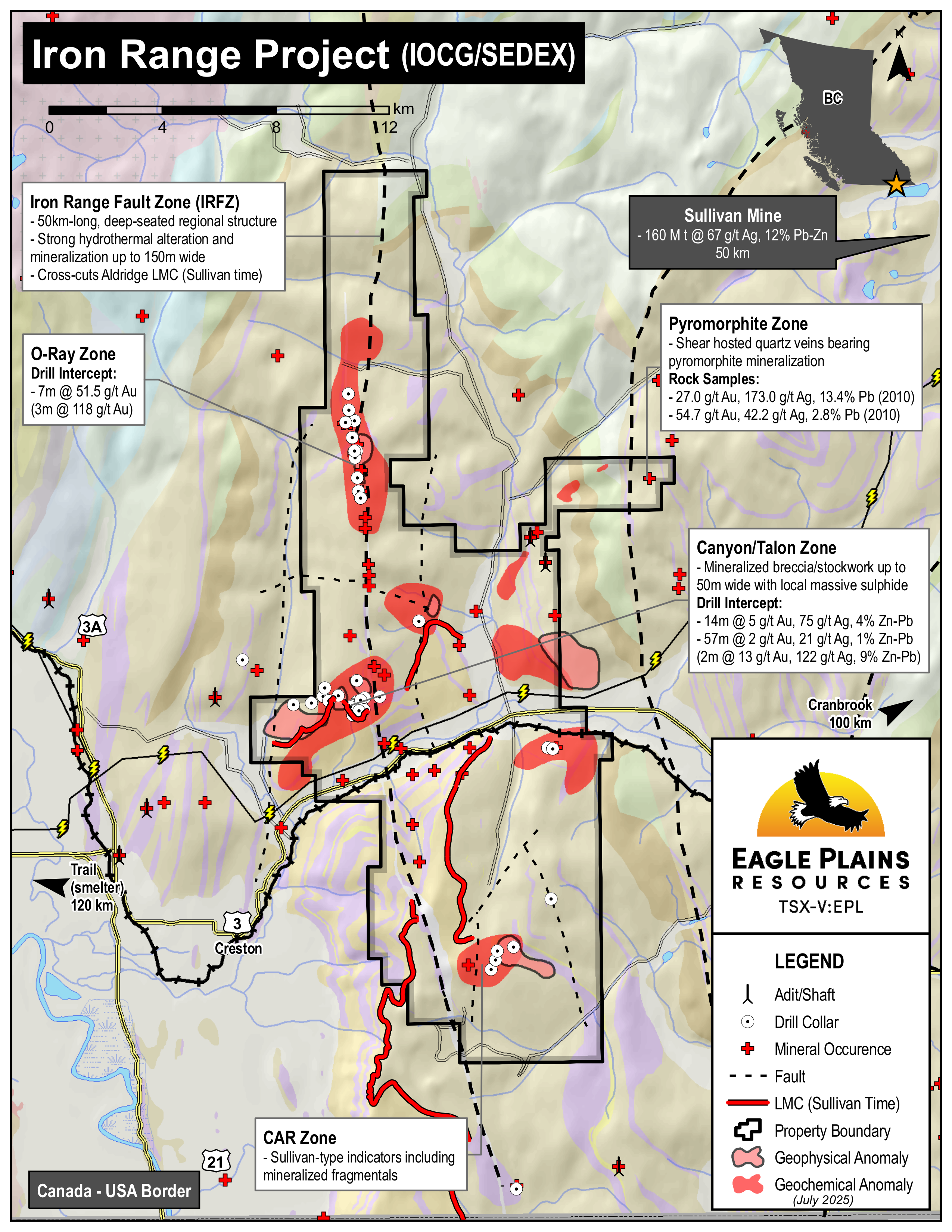
The 20,021ha Iron Range Project located near Creston, BC, is owned 100% by Eagle Plains, subject to a 1% NSR held by a third party on a portion of the claim group. A well-developed transportation and power corridor transects the southern part of the property, including a high-pressure gas pipeline and a high-voltage hydro-electric line, both of which follow the CPR mainline and Highway 3. The rail line provides efficient access to the Teck smelter in Trail, B.C. The project is fully permitted with a Multi-Year Area Based (MYAB) permit in place issued by the BC Ministry of Mining and Critical Minerals that includes provisions for geophysical work, mechanical trenching, access trail construction and diamond drilling.
The Iron Range property covers an extensive area approximately 10km x 32km which overlies the regional Iron Range Fault System (“IRFS”). Prior to the acquisition by Eagle Plains in 2001, the property had seen little systematic exploration for other than iron resources known to exist on the property since the late 1800s. Since 2001, Eagle Plains and its partners have completed 21,593m of diamond-drilling in 87 holes, collected 2482 line-km of airborne and surface geophysical data and analysed 10,053 soil geochemical samples, 495 rock samples and 6955 drill core samples.
-
- British Columbia
-
- Available for option: No
-
- Gold,
- Zinc,
- Silver,
- Copper,
- Iron,
- Lead
Project Highlights
- Large property package overlying world-class SEDEX stratigraphy with IOCG potential
- Widespread Sullivan-type (SEDEX) indicators
- High-grade gold intercepts associated with regional-scale Iron Mountain structure
- Multiple targets associated with untested coincident geochemical/geophysical anomalies within prospective stratigraphy
- Excellent infrastructure: road-accessible bisected by rail, highway, gas, hydro with nearby smelter
Summary
The 20,021ha Iron Range Project located near Creston, BC, is owned 100% by Eagle Plains, subject to a 1% NSR held by a third party on a portion of the claim group. A well-developed transportation and power corridor transects the southern part of the property, including a high-pressure gas pipeline and a high-voltage hydro-electric line, both of which follow the CPR mainline and Highway 3. The rail line provides efficient access to the Teck smelter in Trail, B.C. The project is fully permitted with a Multi-Year Area Based (MYAB) permit in place issued by the BC Ministry of Mining and Critical Minerals that includes provisions for geophysical work, mechanical trenching, access trail construction and diamond drilling.
The Iron Range property covers an extensive area approximately 10km x 32km which overlies the regional Iron Range Fault System (“IRFS”). Prior to the acquisition by Eagle Plains in 2001, the property had seen little systematic exploration for other than iron resources known to exist on the property since the late 1800s. Since 2001, Eagle Plains and its partners have completed 21,593m of diamond-drilling in 87 holes, collected 2482 line-km of airborne and surface geophysical data and analysed 10,053 soil geochemical samples, 495 rock samples and 6955 drill core samples.
Project Highlights
- Large property package overlying world-class SEDEX stratigraphy with IOCG potential
- Widespread Sullivan-type (SEDEX) indicators
- High-grade gold intercepts associated with regional-scale Iron Mountain structure
- Multiple targets associated with untested coincident geochemical/geophysical anomalies within prospective stratigraphy
- Excellent infrastructure: road-accessible bisected by rail, highway, gas, hydro with nearby smelter
Eagle Plains Exploration
Initial field work in 2001 identified IOCG indicators associated with the main Iron Mountain Structure and along the projections of structural splays. This property-scale work also identified SEDEX-style geochemical anomalies along the surface trace of the LMC.
In 2005, drilling tested the LMC for Sullivan-style mineralization. The holes intersected “Sullivan smoke” including disseminated sulphides. One of the holes returned 2.0 m of 3.8 g/t Au and 46 g/t Ag in a fault breccia which is now understood to represent the first intersection of the Talon Zone.
From 2007 to 2009, exploration shifted to the IMFZ in the area of the historic Cominco trenches. Drilling intersected 7.0 m of bonanza-grade gold (51.5 g/t Au) near the O-Ray Iron Oxide showing. Follow-up drilling intersected 1.0 m of 22.5 g/t Au.
Drilling in 2010 intersected intensely altered and mineralized bedrock at the Talon Zone, 400.0 m west of the IRFZ. Semi-massive to massive sulphides, including galena and sphalerite, were reported in borehole IR10-010 over two intervals (14.0 m and 2.0 m - see Talon Zone for details). The lowermost massive sulphide interval is truncated by a fault. The mineralization is interpreted to represent an intermediate sulphidation epithermal system. The source of the metals remains to be determined; however the mineralization observed to date is located within +/- 150 metres of the prolific LMC.
The 2011-2013 exploration programs included diamond-drilling to further define the significant polymetallic mineralization at the Talon Zone and test the ROW Zone. Extensive soil sampling, geological mapping and geophysics were completed with the focus of defining SEDEX-style exploration targets. In 2013, Eagle Plains collaborated with the Mineral Deposit Research Unit (MDRU) from the University of British Columbia evaluate the potential of the IMFZ to host large IOCG deposits.
The work completed by MDRU in 2013 indicated that future IOCG exploration on the Iron Range should take into account the ore deposit models for hematite, Au-rich systems. Exploration should focus within structural traps such as fault jogs, bends, flexures, intersections and step overs that coincide with known geochemical anomalies.
In 2014, a comprehensive and project-wide program to compile and assess all past work on the property was completed. This identified three areas as high-priority exploration targets for both base/precious-metal mineralization, these areas are the Talon/Canyon, O-Ray (Golden Cap) and Car zones. A field program was conducted to collect 10 heavy mineral concentrate samples (HMC) over two of the target areas.
In 2016, a field program was completed to assess several areas of the property. Field work was directed toward extending soil coverage in areas of the property with open anomalies. High priority areas included Anchor Creek and the Pyromorphite mineral occurrence. Bedrock mapping was completed at the Talon Zone to further constrain the geologic model and facilitate borehole planning. Bulk stream sediment samples were collected from four drainage basins within the northern portion of the property to provide baseline data to further constrain detailed geology mapping, prospecting and geochemical surveys. The active exploration permit was amended in 2016 to incorporate new recommendations for exploration activity in proximity to the Talon/Canyon target area.
In 2017, ground-based high resolution I.P. geophysical surveying identified three anomalies, one of which was interpreted to be located downplunge of the known body of mineralization at the Talon Zone. In June 2018, two of these anomalies were successfully tested with a 2-hole diamond drill program with the results returning several intersections of anomalous but not economic Au/Ag values. A third anomaly located approximately 1km to the northwest and at an interpreted depth of approximately 500m is permitted and drill ready but remains untested.
In June 2018, a two hole drill program was conducted to test the targets developed in 2017 and extend the Talon structural zone. The first hole successfully intersected the Talon zone approximately 275m downplunge of the 2010 discovery area and 500 m below where the zone outcrops at surface. Anomalous, but not economically significant gold-silver plus or minus lead-zinc values were encountered at several intervals. The drill hole confirmed the structural geologic model and the effective nature of induced polarization surveys to delineate the shear zone. The second drill hole was designed to test an IP chargeability anomaly and coincident soil anomaly southeast of the Talon zone and intersected a zone of weakly anomalous mineralization interpreted to be a fault-offset or subparallel splay of the Talon zone. A third anomaly located approximately 1km to the northwest and at an interpreted depth of approximately 500m is permitted and drill-ready but remains untested.
In May 2020, the Iron Range was optioned to an arm’s length private Alberta company. In Q2 2021, Eagle Plains received final data/reporting/interpretation from the 2020 Iron Range field program which was wholly funded by this option partner. 2020 work at the Iron Range included soil, rock, and stream sediment geochemistry, a Quantum Geoelectrophysics (QGEP), or Quantum Direct Matter Indicator (QDMI) non conventional geophysical survey, and a 10 hole, 738m diamond drilling program. Although the results from the 2020 work were inconclusive, further work was recommended to continue to advance the Iron Range project.
Geophysical Anomalies and Drill Targeting Animation
In 2022, Eagle Plains option partner, an arm’s length private Alberta company, completed a 2618m 4 hole drill program. This program targeted the Sullivan-style sedimentary-hosted base metal mineralization and structurally-hosted gold mineralization associated with the Iron Range fault structure. Two holes were abandoned short of target depth due to drilling complications. Ultimately, the drill program did not return significant results.
In March 2025, Eagle Plains entered into an option agreement with Earthwise Minerals Corp. for the Iron Range Project, pursuant to which Earthwise was granted the exclusive right to acquire up to an 80% interest in Eagle Plains’ wholly-owned Iron Range gold project (See Mar. 3rd, 2025 news release).
Results from the 2025 field program, as reported on Nov 17th, provided a detailed follow up of historic soil geochemical and till anomalies, prospecting and mapping along structural splays of the Iron Range Fault, and evaluation of historical mineral occurrences. Work was carried out at the Pyromorphite, Star West, DIP and Golden Cap Zones. A total of 531 soils, 15 rocks and 5 heavy mineral concentrates were collected by Terralogic Exploration Inc. geological crews.
2025 Field Program Results Map
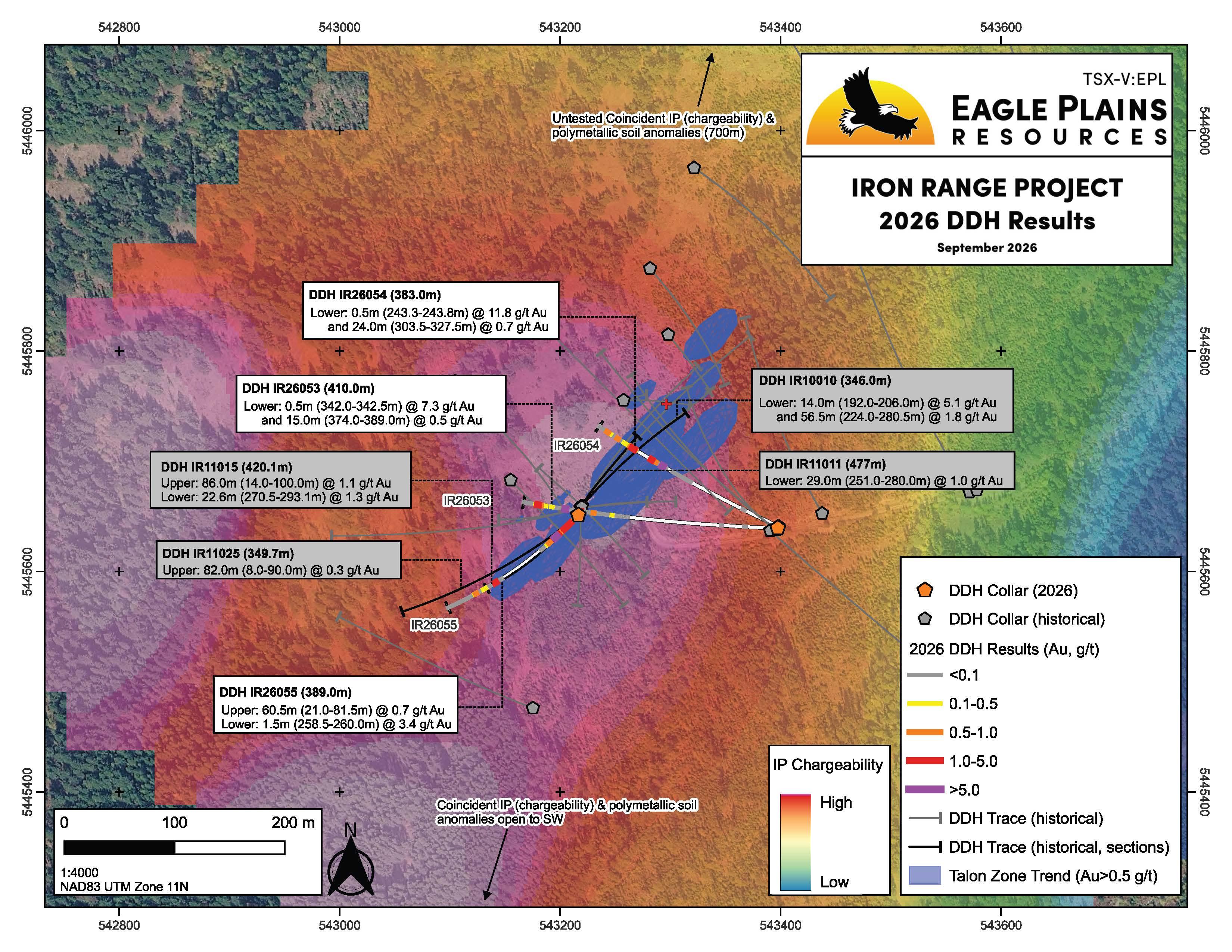
On April 30, 2026, partner Earthwise Minerals Corp. (CSE: WISE; FSE: 966; OTCQB: EWISF) approved a 2026 exploration program comprising a minimum of 1,200 metres of diamond drilling at Iron Range, managed by TerraLogic Exploration Inc. and fully funded by Earthwise. Two of the three planned holes were designed to cross-cut the Talon Zone structure and infill gaps in the historic drilling; the third was designed to test downdip and along strike of known mineralization, targeting a coincident resistivity-conductivity Induced Polarization (IP) anomaly. Drilling commenced May 11, 2026, contracted to QB Drilling, and was completed in June 2026 as three holes totalling 1,182 metres.
2026 Drill Results
Table 1 Drill Hole Information
| Hole ID | Easting* | Northing* | Elev. (m) | Az. (°) | Incl. (°) | Length (m) |
| IR26053 | 543397 | 5445640 | 1371 | 270 | -56 | 410 |
| IR26054 | 543398 | 5445641 | 1371 | 295 | -61 | 383 |
| IR26055 | 543216 | 5445651 | 1369 | 223 | -67 | 389 |
|
TOTAL |
1182 | |||||
*Collar locations projected in NAD83 UTM Zone 11N
On September 2, 2026, Eagle Plains and Earthwise announced assay results: all three holes intersected gold mineralization.
- IR26053: 15 m @ 0.53 g/t Au, including 0.50 m @ 7.26 g/t Au
- R26054: 24 m @ 0.73 g/t Au, including 0.50 m @ 11.75 g/t A
- IR26055: 60.5 m @ 0.76 g/t Au, including 1.0 m @ 6.62 g/t A
- Results point to potential for multiple ore shoots within the broader Talon Zone structure
Table 2 Analytical Results
| Hole ID | From (m) | To (m) | Int (m)* | Ag (g/t) | Au (g/t) | Pb (%) | Zn (%) | |
|
IR26053 |
296.00 |
297.00 |
1.00 |
12.10 |
0.55 |
0.31 |
0.89 |
|
| and |
318.00 |
319.00 |
1.00 |
13.57 |
0.94 |
0.52 |
0.73 |
|
|
incl |
318.00 |
318.50 |
0.50 |
26.80 |
1.88 |
1.04 |
1.45 |
|
| and |
338.50 |
398.00 |
59.50 |
6.92 |
0.26 |
0.05 |
0.13 |
|
|
incl |
338.50 |
342.50 |
4.00 |
7.68 |
1.03 |
0.08 |
0.10 |
|
|
incl |
342.00 |
342.50 |
0.50 |
49.90 |
7.26 |
0.67 |
0.81 |
|
|
and incl |
374.00 |
389.00 |
15.00 |
1.65 |
0.53 |
0.09 |
0.21 |
|
|
incl |
386.00 |
389.00 |
3.00 |
3.02 |
0.90 |
0.08 |
0.17 |
|
|
incl |
386.00 |
387.50 |
1.50 |
3.45 |
1.08 |
0.13 |
0.32 |
|
|
IR26054 |
243.25 |
243.75 |
0.50 |
79.90 |
11.75 |
3.20 |
0.02 |
|
| and |
258.50 |
269.00 |
10.50 |
0.99 |
0.51 |
0.01 |
0.01 |
|
|
incl |
267.00 |
269.00 |
2.00 |
0.49 |
1.11 |
0.00 |
0.00 |
|
|
incl |
267.00 |
268.00 |
1.00 |
0.89 |
1.42 |
0.00 |
0.00 |
|
| and |
303.50 |
327.50 |
24.00 |
5.42 |
0.73 |
0.18 |
0.25 |
|
|
incl |
305.00 |
309.50 |
4.50 |
4.63 |
2.73 |
0.08 |
0.06 |
|
|
incl |
305.00 |
306.50 |
1.50 |
8.15 |
4.47 |
0.18 |
0.17 |
|
| and |
362.90 |
365.70 |
2.80 |
0.84 |
0.55 |
0.01 |
0.01 |
|
|
IR26055 |
19.50 |
104.00 |
84.50 |
4.33 |
0.60 |
0.08 |
0.12 |
|
|
incl |
21.00 |
81.50 |
60.50 |
4.58 |
0.76 |
0.09 |
0.14 |
|
|
incl |
27.00 |
29.00 |
2.00 |
18.34 |
1.40 |
0.03 |
0.05 |
|
|
and incl |
41.00 |
47.50 |
6.50 |
4.42 |
1.43 |
0.03 |
0.07 |
|
|
incl |
44.50 |
45.50 |
1.00 |
21.31 |
3.40 |
0.08 |
0.12 |
|
|
and incl |
72.20 |
80.00 |
7.80 |
13.10 |
2.22 |
0.46 |
0.46 |
|
|
incl |
72.20 |
73.70 |
1.50 |
7.67 |
3.67 |
0.04 |
0.37 |
|
|
and incl |
76.20 |
78.20 |
2.00 |
35.37 |
4.08 |
1.20 |
0.81 |
|
|
incl |
77.20 |
78.20 |
1.00 |
67.10 |
6.62 |
2.11 |
1.13 |
|
| and |
258.50 |
260.00 |
1.50 |
1.82 |
3.09 |
0.01 |
0.01 |
* All drill indicated intercepts as reported in this news release are measured along core length and true thickness is yet to be determined.
All drillholes collared in Middle Aldridge and ended in Lower Aldridge Formation sediments, typical of the Purcell Basin turbidite stratigraphy. Talon Zone style mineralization is defined by strong silica-feldspar alteration associated with chaotic quartz-feldspar-ankerite veins. Polymetallic mineralization (pyrrhotite-pyrite-sphalerite-galena-arsenopyrite-sulfosalts) is typical throughout the structural zone as veins, fracture infill and localized breccia cement. The Talon Zone structure is interpreted to be a NE-SW trending structural splay off the regional Iron Range Fault and is marked by a multi element soil geochemical anomaly and coincident geophysical Induced Polarization (IP) chargeability and resistivity anomalies. The IP chargeability + resistivity anomaly remains open to the southwest and north and drilling has only tested <10% of the broader multi element soil geochemical anomaly.
DDH IR26053 was designed to cross-cut the Talon Zone structure, infilling historical holes IR11011 and IR11015. At target depth the boreholes are spaced approximately 120m along trend. IR26053 successfully infilled the historical drilling, piercing target stratigraphy ~70m NE of IR11015 and ~50m SW of IR11011. Geochemical results defined a number of anomalous zones of gold mineralization, confirming continuity of gold mineralization between historical holes. The interval from 342.0 - 342.5 returned 7.26 g/t Au and 49.9 g/t Ag, associated with semi-massive pyrrhotite veining in weakly altered Aldridge sediments. Interval 374.0 - 389.0 returned 0.53 g/t Au over 15m and is associated with intense, pervasive silica and feldspar alteration of Aldridge sediments that is typical of mineralized stratigraphy within the main (lower) Talon Zone.
DDH IR26054 was designed to cross-cut the Talon Zone structure, infilling between historical holes IR10010 and IR11011. At target depth the boreholes are spaced approximately 60m along trend. IR26054 successfully infilled the historical drilling, piercing target stratigraphy ~ 30m NE of IR11011 and ~30m SW of IR10010. An interval of well developed pyrrhotite veining in weakly altered Aldridge sediments returned 11.75 g/t Au and 79.9 g/t Ag over 0.5m from 243.25 - 243.75m. Geochemical results from the main (lower) Talon Zone Structure, intercepted between 258-345m, include 24m at 0.73 g/t Au from 303.5 – 327.5m. Within this broader interval, 305.0 - 306.5 returned 4.47 g/t Au over 1.5m. Mineralization in the main (lower) Talon Zone horizon is associated with strong, pervasive silica-felspar alteration and chaotic swarms of variably mineralized quartz-feldspar-carbonate veins and lesser breccia cement.
DDH IR26055 was designed to overcut IR11015, assessing continuity of an upper mineralized structural trend to the southwest, an area that is historically underexplored. The hole successfully intercepted an upper and lower mineralized horizon first defined in DDH IR11015. The hole was collared in the upper mineralized horizon (15-104m), where polymetallic mineralization (pyrrhotite-pyrite-sphalerite-galena-arsenopyrite-sulfosalts) is associated with intense oxidization of sulphides and strong silica and feldspar alteration of the Middle Aldridge sediments. The strong-intense alteration associated with polymetallic mineralization is consistent with the mineralization style observed at the main (lower) Talon Zone horizon and could indicate the potential for multiple ore shoots within the broader Talon Zone Structure. Geochemical results from the upper horizon included 60.5m of 0.76 g/t Au from 21.0 – 81.5m. including 1.0m at 6.62 g/t Au and 67.1 g/t Ag from 77.2 – 78.2m.
The main (lower) Talon Zone mineralized horizon was intercepted between 241-380m, a 40m step-out from IR11015. The best results were 3.09 g/t Au over 1.5m from 258.5 – 260.0m.
Quality Assurance and Quality Control
All drill core samples were analyzed at ALS Canada Ltd. in North Vancouver, BC. The sampling program was undertaken by TerraLogic Exploration personnel under the direction of Kerry Bates, P.Geo. QA/QC protocols are maintained through the insertion of certified reference material (standards), blanks and coarse reject duplicates within the sample stream. Drill core is cut in-half with a diamond saw with one-half placed in sealed bags and shipped to the laboratory and the other half retained in permanent core store in Cranbrook, BC. A secure chain of custody is maintained in transporting and storing of all samples.
The entire sample is crushed to 70% passing 2mm (10 mesh), of which a 250g split is pulverized to 80% passing 75 micron (200 mesh). Multi-element analyses were determined by 4-acid digestion followed by Inductively Coupled Plasma Mass Spectrometry (ICP-MS), reporting 48 elements. Samples with >9,500 ppm As, Cu, Zn Pb were further analyzed with Inductively Coupled Plasma – Atomic Emission Spectroscopy (ICP-AES). Samples with > 95ppm Ag were further analyzed with Inductively Coupled Plasma – Atomic Emission Spectroscopy (ICP-AES). Au is determined by fire assay on a 50g split utilizing Atomic Absorption Spectroscopy (AAS). Samples with >9 ppm Au were further analyzed using fire assay fusion with gravimetric analysis.
Iron Range Option Agreement Details
Earthwise Minerals Corp. (CSE: WISE; FSE: 966; OTCQB: EWISF) holds the exclusive option to acquire up to an 80% interest in the Iron Range Project. Under the First Option, Earthwise can earn a 70% interest by paying CA$250,000, issuing 1,500,000 common shares to Eagle Plains, and funding CA$4,000,000 in exploration expenditures over a four-year term. Under the Second Option, Earthwise can earn an additional 10% (80% total) by notifying Eagle Plains of its intent, making a further one-time payment of CA$1,000,000 cash, and completing a bankable feasibility study on the property before the eighth anniversary of the option.
If either option is exercised, a 2% smelter returns royalty will be granted to Eagle Plains over the entire property, 1% of which is repurchasable for CA$1,500,000. Eagle Plains serves as Operator under the terms of the option and reserves the right to use TerraLogic Exploration Inc. as geoscience consultant. Following exercise of either option, Earthwise and Eagle Plains will form a 70/30 or 80/20 joint venture to further explore and develop the property.
Details
Geology
Iron Mountain Fault
The Iron Range property covers over 50 km strike-length of the IMFZ: a north-south striking fault corridor with an east-west extent of about 3 km and a strike extent of approximately 90 km. Within the property boundaries the central core of the IMFZ outcrops as a hydrothermal breccia up to 150 m wide containing iron oxide and iron sulphide mineralization. The IMFZ also cross-cuts the Proterozoic Lower – Middle Aldridge Formation, which is the stratigraphic host for the world-class Sullivan deposit, located approximately 65 km NE of the property.
Below is a synopsis of the property geology:
Sedimentary Exhalative (SEDEX) Geology
Geological and structural mapping indicate that the IMFZ has influenced the emplacement of Moyie intrusions, sedimentary fragmental formation, alkaline intrusions, hydrothermal breccias and related hydrothermal alteration/mineralization. All of these characteristics indicate that the IMFZ has undergone multiple reactivations throughout its history.
The combination of well-developed "Sullivan smoke" including tourmaline alteration, albite alteration, sedimentary fragmental units, disseminated sulphides and an extensive multi-element soil geochemical anomaly coincident with the LMC or “Sullivan time”, and the presence of a major deep-seated regional scale structure indicates the possibility of a nearby vent system similar to the one that formed the Sullivan deposit.
Animation of a SEDEX Deposit Forming
Iron Oxide Copper Gold (IOCG) Geology
The IMFZ hosts significant iron mineralization, which in several locations is associated with anomalous precious metals. Hydrothermal alteration within and adjacent to the Iron Mountain Fault includes: chloritization, intense silica flooding and replacement, hematite-magnetite-albite, sericite-carbonate overprinting and intense argillic alteration. Felsic intrusions in proximity to or in contact with major iron oxide fault zones are known to generate significant copper precious-metal deposits. Felsic-intermediate intrusions flank the western margin of the north and central portions of the property, analogous to the geological setting of the Candelaria deposit in Chile. Work completed in 2013 by the Mineral Deposit Research Unit has indicated the potential for precious metal enriched iron oxide type mineralization on the property.
Intermediate Sulphidation Epithermal Geology
Fault splays associated with the IMFZ contain metals and alteration minerals indicative of epithermal style mineralization. Base metals (sphalerite and galena) and precious metals (gold and silver) have been deposited within brittle shear zones as disseminated to massive sulphide/sulphoslats hosted within silica-k-feldspar-sericite-carbonate altered and brecciated metasedimentary rocks of the Aldridge Formation.
History
The original Iron Range prospect was discovered and staked in 1897 along an extensive belt of iron showings. In 1939, CM&S (later Cominco) along with its parent company, the CPR, acquired many of the historical Crown Grants on the northern part of Iron Range Mountain. The claims were evaluated by CM&S to assess the potential for a large iron resource. In 1957 Cominco completed an extensive trenching program exposing the Iron Mountain Fault structure and mineralization over more than 4 km strike-length. Most of the Iron Range Crown Grants were held by Cominco until 1999, when they were reverted after being held privately for over 100 years. Eagle Plains re-staked the original Crown Grants on the day they lapsed and has subsequently expanded its’ tenure holdings.
Iron Range Zones
Canyon/Talon Zone
The Talon Zone is located within the greater “Canyon” target area an forms an elongate breccia approaching 50 m wide along a NE trend approximately 400 m west of the IMFZ. Base and precious metal mineralization (Ag-Au-Pb-Zn) is associated with texture destructive silica-K-feldspar-sericite-carbonate alteration. Structures are observed as zones of brittle deformation from one metre up to tens of metres wide which directly control the distribution of mineralization. The structural setting, geochemical signature and associated alteration minerals are indicative of an intermediate sulphidation epithermal hydrothermal system. The source of the metals remains to be determined; however the mineralization observed to date is located within +/- 150 metres of the prolific LMC.
| Sample Type | Results | Description of Zone and Sampling |
|---|---|---|
| Drill Intercept | 14m* @ 5.1 g/t Au, 1.86% Pb, 2.1% Zn, 75.3 g/t Ag | 192m to 206m vein hosted massive sulphide |
| Drill Intercept | 56.5m* @ 1.9 g/t Au, 0.44% Pb, 0.59% Zn, 21.5 g/t Ag | 224m to 280.5m overlain by disseminated and breccia hosted mineralization within intensely silica-k-feldspar altered rock. |
| Drill Intercept | 2m* @ 12.8 g/t Au, 4.18% Pb, 5.06% Zn, 122.5 g/t Ag and elevated Cd, Sb, Sn, Bi and Cu | Included within the 56.5m intercept - 277.5m to 279.5m massive-sulphide truncated by a fault |
* the intersections are not representative of true thickness
Golden Cap/O-Ray Zone
At the Golden Cap, zones of hydrothermal brecciation up to 30 m wide within the Iron Range Fault Zone are associated with favourable IOCG type alteration including hematitizaiton of magnetite, albite, chlorite, carbonate, sericite and pyrite. The high grade Au-Ag intersection defined during the 2008 drilling program occurs in a strongly altered shear-zone found in the hanging wall of the IMFZ. The shear-zone is sub-vertical and occurs as a quartz stockwork zone within feldspar, sericite, chlorite, and limonite altered metasedimentary rock. Airborne geophysical VTEM surveys have indicated that the Golden Cap is centered on the intersection of two major regional structures and is associated with a multi-element geochemical anomaly enriched in IOCG related pathfinder elements.
| Sample Type | Results | Description of Zone and Sampling |
|---|---|---|
| Drill Intercept | 7m* @ 51.52 g/t Au, 2.39 g/t Ag | Near surface high-grade Au mineralization |
| Drill Intercept | 4m* @ 89.98 g/t Au, 4.17 g/t Ag | Included within the 7m drill intercept |
| Drill Intercept | 3m* @ 118.45 g/t Au and 5.56 g/t Ag | Included within the 7m drill intercept |
* the intersection is not representative of true thickness
Pyromorphite Zone
Past exploration includes reconnaissance soil sampling and prospecting. In 2009 a previous operator sampled outcrop and float that was exposed during construction of a new network of forest service roads. Bedrock consists of quartzites and argillites of the Alridge Formation. At the Pyromorphite Occurrence the sediments have been sheared by an apparent northeast trending structure resulting in brecciation of sediments. Mineralization is dominantly pyromorphite, hosted in cm-scale quartz veins within the sheared and brecciated sediments.
| Sample Type | Results | Description of mineralization |
| Grab | 27.0 g/t Au, 173.0 g/t Ag, 13.4% Pb | Shear hosted quartz veins bearing pyromorphite mineralization |
| Grab | 54.7 g/t Au, 42.2 g/t Ag, 2.8% Pb | Shear hosted quartz veins bearing pyromorphite mineralization |
Car Zone
Past exploration includes regional silt sampling by the Geological Survey of Canada, detailed soil sampling, geophysical surveys, geologic mapping and a 2400 m diamond-drill program. Mineralization style, geologic and tectonic settings are all similar to that of the Sullivan deposit. Iron and base metal sulphides are hosted by a large Sullivan-type fragmental complex. The fragmental complex outcrops in the headwaters of Russell Creek and can be traced over a distance of approximately 1.2 km. Airborne surveys have defined a number of geophysical gravity and VTEM anomalies. The favorable LMC target horizon is located at approximately 500 – 1200 m depth from surface in an area that appears to be the intersection of major regional structural trends.
Eagle Plains - A Project Generator
Eagle Plains Resources is a project generator with several mineral exploration properties of merit that meet qualifying transaction requirements. We facilitate the listing process for capital pool companies and initial public offerings while providing technical expertise for exploration programs. Companies interested in co-operatively exploring any of our projects please contact: Chuck Downie at ccd@eagleplains.com or Andrew Wilson at abw@eagleplains.com or call 1 866 Hunt Ore (486 8673).
Updated Sept. 3, 2026
Photos


