Hearne Hill South Project
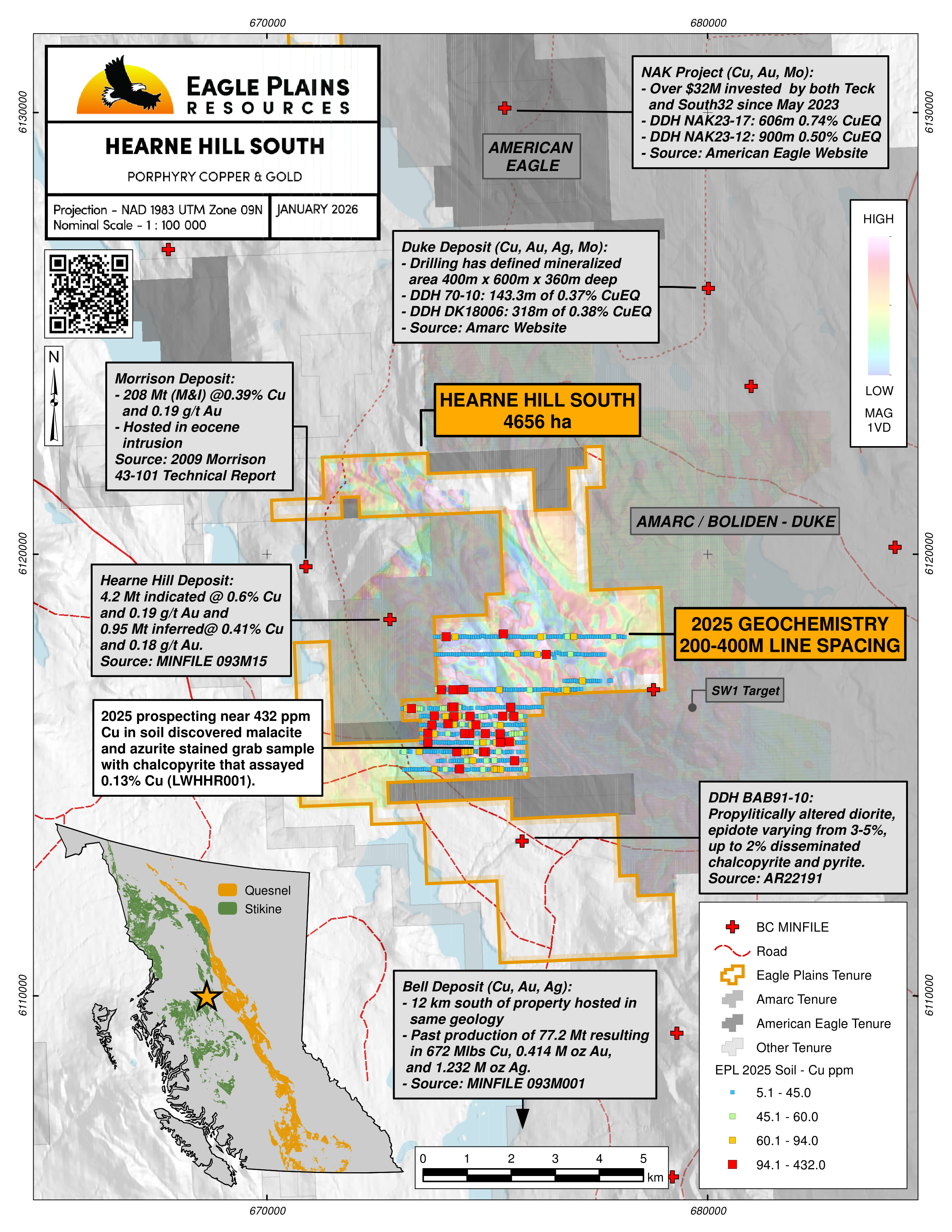
The 4,656 ha Hearne Hill South Project is located in central British Columbia, approximately 70 km northeast of Smithers and 20 km north of the past producing Bell and Granisle copper mines. The property is less than 2 kms from the Morrison and Hearne Hill deposits, highlighting the significant regional and local potential to host Cu-Au porphyry-type mineralization. The property can be accessed by truck utilizing a network of forest service roads from Highway 118 at Topley Landing, which are primarily used to service the past producing mines and active logging operations in the area.
The claims were acquired in 2023-2025 through a combination of staking and third-party purchase agreements and are owned 100% by Eagle Plains with no underlying royalties or encumbrances.
-
- British Columbia
-
- Available for option: Yes
-
- Copper,
- Gold
Project Highlights
- Located in the Stikine Terrane, proximal to past producing mines and developed prospects
- Road accessible with nearby hydro transmission lines
- Under-explored geophysical anomalies consistent with prospective intrusive geology
Details
The 4,656 ha Hearne Hill South Project is located in central British Columbia, approximately 70 km northeast of Smithers and 20 km north of the past producing Bell and Granisle copper mines. The property is less than 2 kms from the Morrison and Hearne Hill deposits, highlighting the significant regional and local potential to host Cu-Au porphyry-type mineralization. The property can be accessed by truck utilizing a network of forest service roads from Highway 118 at Topley Landing, which are primarily used to service the past producing mines and active logging operations in the area.
The claims were acquired in 2023-2025 through a combination of staking and third-party purchase agreements and are owned 100% by Eagle Plains with no underlying royalties or encumbrances.
Project Highlights
- Located in the Stikine Terrane, proximal to past producing mines and developed prospects
- Road accessible with nearby hydro transmission lines
- Under-explored geophysical anomalies consistent with prospective intrusive geology
Geology
The Hearne Hill South property is located within the Babine Porphyry Belt consisting of Tertiary and Cretaceous age porphyry occurrences in central BC. Intermediate intrusions of the prospective Babine Intrusive Suite intrude packages of volcanic and sedimentary rocks that comprise the Stikine Terrane, an island arc assemblage. The Hearne Hill South project is situated on the northern edge of the Skeena Arch, separating rocks of the younger Bowser Basin on the north from the Nechako Trough to the south. Jurassic aged uplift resulted in extension and faulting that act as the main control on the emplacement of Cretaceous and Tertiary age intrusions in the region.
Rocks of the Stikine Terrane primarily consist of Late-Triassic (Takla Group) and Early-Jurassic (Hazelton Group) marine volcanic, volcaniclastic and sedimentary rocks. Overlaying the Takla and Hazelton, the Mid- to Late-Jurassic Bowser Lake and Mid-Cretaceous Skeena groups are dominated by marine and non-marine sedimentary rock sequences that deposited in basins bound by north-northwest trending faults. Bowser and Skeena Group sediments are overlain by the Eocene Newman Formation, consisting of rhyolitic and andesitic volcanic rocks which formed during the emplacement of the intrusive Babine Suite.
Intrusive rocks in the area consist of six major suites spanning ages from the Late Triassic to Eocene and include the Topley (173-206 Ma), Omineca (121-181 Ma), Bulkley (70-84 Ma), Goosley Lake (49-53 Ma), Nanika (47-56 Ma), and Babine (49-55 Ma). While economic metal deposits have been associated with rocks from each of these intrusive events regionally, the Eocene age Babine Igneous Suite is the most prospective for porphyry copper mineralization of economic significance in the project area. Babine Suite intrusive units range from equigranular, fine- to medium-grained quartz diorite and quartz monzonite, porphyritic rhyolite and dacite dykes, and most notably a crowded biotite-feldspar porphyry (BFP).
Alteration associated with the mineralized porphyries of the Babine Igneous Suite follow that of a typical porphyry emplacement model, with a central potassic core defined by hydrothermal biotite +/- K-feldspar that grades outwards into phyllic (quartz-sericite-pyrite) and propylitic (chlorite-carbonate-epidote) assemblages. Cu mineralization is typically associated with the potassic centers but can also be found within phyllic alteration zones along the margins of the potassic core.
Structurally, Cu mineralization follows the northeast to northwest regional faults, which can be recognized in various geophysical data sets. Higher grades zones are noted to occur at contacts between intrusive rocks and the volcanic-sedimentary sequences of the Hazelton group.
Within the project boundaries the geology is dominated by volcanic and lesser sedimentary rocks of the Lower to Middle Jurassic Telkwa Formation (Hazelton Group). The volcanic rocks in the area consist primarily of grey lapilli crystal tuff and andesites. Local stocks of dioritic to quartz dioritic Triassic to Early Jurassic Topley Suite and Babine Igneous Suite intrusions have intruded the Hazelton Group rocks. Mapped intrusive rocks generally consist of biotite-feldspar porphyries (BFP) that form a predominant series of north-east trending dykes and plugs through the core of the Hearne Hill South Property. Magnetic geophysical data indicates that the distribution of intrusive rocks may be wider spread than surface mapping results indicate. Detailed geological mapping is warranted to further understand distribution of favourable geological units.
Mineralization
Two MinFile occurrences are documented within the current Hearne Hill South tenure boundaries, known as the Bab and Jake showings (Table 3). The Bab occurrence (BC MinFile 093M127), located 2 km east of northern Babine Lake, primarily consists of Lower Jurassic Telkwa Formation volcanics intruded by Eocene Babine Intrusions. A northwest-trending shear zone hosts significant mineralization including pyrite and chalcopyrite. A 1991 drill hole targeting an IP anomaly intersected propylitically altered diorite with disseminated pyrite and chalcopyrite, near surface. (BC MinFile 093M005). The Jake showing (BC MinFile 093M127), situated 5 km NE of Hatchery Arm on Babine Lake, displays minor mineralization of pyrite, chalcopyrite, and malachite infilling fractures within the stratified andesitic to rhyolitic flows and tuffs. Five additional MinFile occurrences of interest are documented proximal to the Hearne Hill South property; including the Hearn Hill (deposit), Morrison (deposit), Wolf (prospect), Nak (deposit) and David (showing) occurrences.
Significant mineralization in the region has been recognized in two forms: (1) stockwork porphyry Cu+Mo mineralization typical of that associated with BFP intrusions in the Babine; and (2) breccia pipes containing higher grade Cu+Au that form the core of the Hearne Hill porphyry deposit. Within the porphyry style hydrothermal system, the BFP intrusions and to a lesser degree the intruded Hazelton volcanic rocks, host chalcopyrite, pyrite, bornite, and minor molybdenite within quartz veinlets, fracture fill and disseminations. Strong biotite and quartz-sericite alteration is associated with mineralization, with potassic alteration being associated with the best grades. The alteration intensity decreases outwards into lesser mineralized quartz-sericite and propylitic zones. Mineralization hosted within stockwork veins are typically best within the volcanic and sedimentary country rocks, likely the result of higher porosity relative to the intrusions.
At the Hearne Hill Deposit two breccia bodies, the Chapman and Peter Bland zones, are situated within and adjacent to the porphyry Cu stockwork zone. Both breccia zones are elongated along a principal NNE trending fracture system and are noted to host Cu+Au mineralization. The breccia pipes plunge steeply to the east and are generally monolithic, containing angular clasts of the immediate wall-rock of dominantly BFP and lesser Hazelton volcanic rocks. The clasts are cemented by chalcopyrite, pyrite, lesser carbonate and dolomite with minor chalcedony.
At the Morrison Deposit mineralization is dominated by chalcopyrite and pyrite with lesser bornite. Chalcopyrite is noted within BFP intrusions and the sedimentary country rocks, hosted in stockwork veinlets and fractures. Copper grades are noted to be best within potassic (biotite-K-feldspar) alteration zones.
Regional Exploration History
Between 1967-1972 exploration efforts by various operators investigated the geological potential of region. Surficial geochemical assessment was successful in confirming Cu-mineralization potential related in intrusive rocks. Various geophysical work programs including ground magnetometer, ground/airborne electromagnetic and IP surveys were completed to further assess anomalous mineralization highlighted in the results of the geochemical work programs.
In 1981, Noranda Minerals Limited completed an exploration field program on the Lake Mineral Claims including regional and property geological mapping, soil geochemistry, ground magnetometer, and reconnaissance induced polarization surveys. Multiple target areas, associated with magnetic lows were identified.
In 1989, focusing on the Hearne Hill Deposit area, Noranda Minerals Inc. completed soil sampling and mechanical trenching. The work program successfully defined Cu-in-soil anomalies that were tested in 6 diamond drill holes, totaling 468 m. Four holes intersected mineralized breccia and represents a previously unrecognized deposit style in the Babine region.
In 1991-1992, Noranda Minerals Inc. completed a reconnaissance geological mapping and prospecting program on the Morrison Group Claims. Prospecting and geological mapping were successful in locating Cu-bearing BFP rocks north of the Morrison Deposit. The program confirmed chalcopyrite and pyrite mineralization associated with argillic alteration facies of BFP. A single drill hole (BAB91-10), drilled outside of the current Hearne Hill South tenure, was completed to test IP chargeability anomalies associated with elevated Cu-in-soils. The hole, positioned within the south portion of the current Hearne Hill South tenure boundary, intersected a dioritic dyke with weakly anomalous chalcopyrite mineralization associated with propylitic alteration.
In 1993 Booker Gold carried out extensive trenching at the Hearne Hill Deposit, investigating the potential for additional breccia pipe mineralization. A total of 14 trenches were excavated in the vicinity of the mineralized breccia previously discovered by Noranda. Mineralization exposed by the trenching program included fracture filling and disseminated Cu mineralization in altered feldspar porphyry and altered Hazelton andesite volcanic country rocks. Several boulders containing chalcopyrite and pyrite were uncovered, returning up to 20.6% Cu, 0.146 oz/ton Au and 1.75 oz/ton Ag. Follow up drilling of 21 diamond drill holes were completed in the areas surrounding the trenches. DDH PH 20 drilled on the main breccia body at the Hearne Hill Deposit intersected 70.1 m of 2.1% Cu and 0.014 oz/ton Au.
In 1995 Teck Exploration Ltd. completed a regional airborne geophysical program in the Babine Porphyry Belt, collecting magnetic and radiometric data. Results from the magnetic data proved an effective tool for interpreting regional lithologies and structures. Radiometric data (K count) showed a strong anomaly over the well exposed Bell deposit; similar, but weaker responses are present over other major prospects.
In 1996, Aerodat Inc., on behalf of Lucero Resource Corp., completed a helicopter-borne geophysical survey over the Nak and Tak claim blocks, overlapping the northern portion of the current claim group. Electromagnetic and magnetic results identified 15 potential targets that are consistent with buried intrusions. Anomalous potassium results from the radiometric survey provides evidence of potential potassic alteration.
In 1997-1998, Booker Gold Exploration Limited conducted exploration at the Hearne Hill Property (Hearne Hill Deposit area), which included geochemical surveying, geophysical survey and diamond drilling. Results indicate significant Cu and Au mineralization of BFP intrusions. Results from the IP survey highlighted a strong, NE trending chargeability anomaly, following the trend of mapped local faults. A significant diamond drilling campaign, totaling in 58 boreholes, tested coincident geochemical and geophysical anomalies and successfully extended the high-grade core zone and located additional mineralized occurrences including a chalcopyrite cemented breccia.
In 1997-1998, Booker Gold Explorations Ltd., on behalf of Noranda Mining and Exploration Inc., conducted a geochemical sampling program over the Morrison Property, focusing on identifying new mineralized breccias. Three diamond boreholes were completed, with reports of mineralized intercepts up to 96m @ 0.72% Cu and 0.53 g/t Au.
In 1999-2003, trenching and diamond drilling were completed at the Morrison deposit by Pacific Booker Minerals. Work included expanding historical trenches and completing 15 diamond drill holes. Reported drill results include up to 273m @ 0.42% Cu and 0.25 g/t Au. Results were used to defined the northern extent of the deposit and further defined the mineralized core of the deposit.
In 2006, Knight Piesold Ltd. completed a geotechnical investigation program at the Morrison deposit, on behalf of Pacific Brooker Minerals Inc (Knight, 2006). The main purpose of the site investigation program was to collect the geotechnical information required for the feasibility level open pit slope design.
In 2017, Amarc Resources Ltd. completed a high resolution heli-borne magnetic survey over parts of the Duke property. The survey highlighted major NE and NW trending structures and associated cross-structures in the Babine Lake area associated with the Skeena Arc development, along with inferred batholitic intrusions underlying the Duke property. Favourable geophysical trends identified during this program are interpreted to trend in a NW orientation onto the current Hearne Hill South Property and warrant field follow-up.
Further exploration by Amarc in 2019 at the Hearne Hill property included the collection of rock, soil and biogeochemical sampling. The program was designed to prove historic anomalous results, to prospect for mineralization along strike to the southwest of the Chapman breccia body and to test the efficacy of biogeochemical sampling within this terrain. Rock sampling confirmed the presence of high copper and gold values at the Chapman Breccia, returning values of >10,000 ppm Cu, 7.1 ppm Ag and 251.9 ppb Au.
In 2022-2023, Amarc Resources Ltd. completed an airborne magnetic survey over the Hearne Hill property. Results of the airborne magnetic survey highlight numerous magnetic features associated with intrusive and volcanic units within the property boundary, both proximal and distal to areas of known mineralization. Following the geophysical survey Amarc completed a comprehensive compilation of historical surface and drilling data from all publicly available data surrounding the project area. The report provides significant data on the claims surrounding the current property boundaries. Some historical anomalies highlighted in this report appear to trend onto the property and warrant field assessment.
Eagle Plains Exploration
In 2025 Eagle Plains Resources completed a high resolution airborne magnetic geophysical survey and soil geochemical surveys. Interpretation of results is pending.
Future Work
- Tier II data compilation including digitizing all available exploration data and creating a digital database
- Continued surficial geochemical surveys to expand on historical anomalies and generate new exploration targets
- Detailed mapping and prospecting in areas with favourable geophysical and geochemical anomalies
- Apply for an exploration permit to conduct surface trenching, IP Geophysics and diamond drilling
Eagle Plains - A Project Generator
Eagle Plains Resources is a project generator with several mineral exploration properties of merit that meet qualifying transaction requirements. We facilitate the listing process for capital pool companies and initial public offerings while providing technical expertise for exploration programs. Companies interested in co-operatively exploring any of our projects please contact: Chuck Downie at ccd@eagleplains.com or Andrew Wilson at abw@eagleplains.com or call 1 866 Hunt Ore (486 8673).
Updated March 19, 2026