Dragon Lake Project
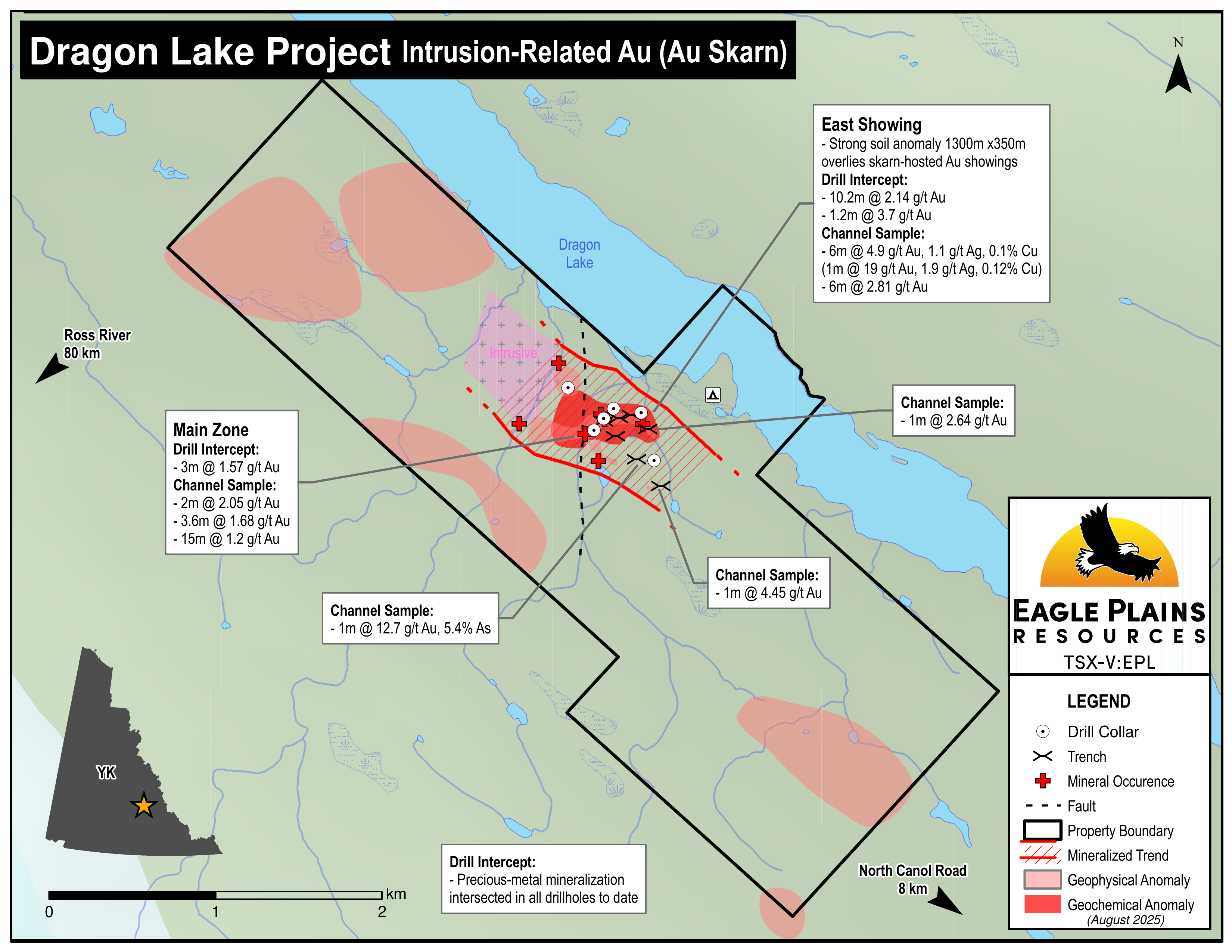
The 898 ha Dragon Lake Property is located 80 km NE of Ross River, YT. It has been explored since the mid 1940’s when Cu and Au mineralization was discovered by the GSC.
Access is by helicopter service from Ross River or Faro, YT. Crews can be mobilized from the North Canol Road located 8 km to the SE. Alternate access is by boat from km 110 on the North Canol Road. An exploration camp has been established on the tenure.
-
- Yukon Territory
-
- Available for option: Yes
-
- Gold,
- Silver,
- Copper
Project Highlights
- Significantly underexplored with encouraging early stage results
- Drill targets identified to test for Tombstone suite intrusion-related gold mineralization
- Untested high-priority geophysical anomalies associated with favorable geology and geochemistry
- Winter road access
- Targets for multiple deposit models
Summary
The 898 ha Dragon Lake Property is located 80 km NE of Ross River, YT. It has been explored since the mid 1940’s when Cu and Au mineralization was discovered by the GSC.
Access is by helicopter service from Ross River or Faro, YT. Crews can be mobilized from the North Canol Road located 8 km to the SE. Alternate access is by boat from km 110 on the North Canol Road. An exploration camp has been established on the tenure.
Project Highlights
- Significantly underexplored with encouraging early stage results
- Drill targets identified to test for intrusion-related gold mineralization
- Untested high-priority geophysical anomalies associated with favorable geology and geochemistry
- Winter road access
- Targets for multiple deposit models
Geology
The rocks exposed at Dragon Lake are Hyland Group clastic and metasedimentary rocks of the Selwyn Basin overlain and intruded by volcanic flows and dykes of undetermined age. The sediments are variably metamorphosed to graphitic and calcareous phyllite, chert, calc-silicate rock, skarn, marble and quartzite. Calc-silicate and skarn units host sulphide (predominantly pyrrhotite) mineralization with gold preferentially enriched along NNW structures.
History
The region was first explored in the 1880’s by prospectors seeking placer Au. Mineralization on the property was first described by the GSC in 1945, and exploration activity in the region increased dramatically in the 1950’s and 60’s with the discovery of the Anvil Pb-Zn deposit at Faro. A subsequent exploration rush occurred in the 1990’s with the discovery of the Kutz ze Kayah and Wolverine massive sulphide deposits and intrusive-hosted Au mineralization in the Tintina Gold Belt.
Eagle Plains Exploration
Eagle Plains acquired the property in 1996 and conducted 7 exploration campaigns between 1997 and 2011, including mapping and prospecting, geochemical and geophysical surveys, hand trenching and 2 diamond-drill programs totalling 908 m. Notable exploration results are tabled below:
| Sample type | Results | Description |
|---|---|---|
| Drill | 2.14 g/t Au over 10.2m | East Showing |
| Trench | 2.81 g/t Au over 6m | East Showing |
| Trench | 4.9 g/t Au, 1.1 g/t Ag and 0.1% Cu over 6m | East Showing |
The 2011 exploration program encountered precious-metal mineralization in all 6 drill holes and located a new skarn-style mineral occurrence overlain by a strong Au-in-soil anomaly. Precious-metal mineralization and anomalous soils form a WNW-trending zone of 1300 m by 350 m.
Future Work
- Detailed mapping of structural geology
- Trenching, bedrock mapping and sampling of the new skarn zone
- Prospecting and mapping of the soil anomalies defined in 2010
- Detailed soil sampling to further refine geochemical targets
- Diamond-drilling to test high-priority targets
Eagle Plains - A Project Generator
Eagle Plains Resources is a project generator with several mineral exploration properties of merit that meet qualifying transaction requirements. We facilitate the listing process for capital pool companies and initial public offerings while providing technical expertise for exploration programs. Companies interested in co-operatively exploring any of our projects please contact: Chuck Downie at ccd@eagleplains.com or Andrew Wilson at abw@eagleplains.com or call 1 866 Hunt Ore (486 8673).
Details
The 898 ha Dragon Lake Property is located 80 km NE of Ross River, YT. It has been explored since the mid 1940’s when Cu and Au mineralization was discovered by the GSC.
Access is by helicopter service from Ross River or Faro, YT. Crews can be mobilized from the North Canol Road located 8 km to the SE. Alternate access is by boat from km 110 on the North Canol Road. An exploration camp has been established on the tenure.
Exploration work in the 1960's and 1980's demonstrated significant mineralization (up to 1.5 g/t Au and 2.5 g/t Au) in skarn pods, veins and sheeted quartz vein systems in contact zones and along structures peripheral to a Cretaceous Granitoid intrusion.
Eagle Plains began exploring the property in 1996. Since then, geochemical and geophysical surveying, trenching and drilling have advanced the understanding of the property and returned significant results.
The claims are 100 % owned by Eagle Plains and carry no underlying royalties or encumbrances.
Project Highlights
- Significantly underexplored with encouraging early stage results
- Drill targets identified to test for Tombstone suite intrusion-related gold mineralization
- Untested high priority geophysical anomalies associated with favorable geology and geochemistry
- Winter road access
- Targets for multiple deposit models
Geology
The rocks exposed at Dragon Lake are Hyland Group clastic and metasedimentary rocks of the Selwyn Basin overlain and intruded by volcanic flows and dykes of undetermined age. The Hyland Group sediments consist of coarse clastic units, ranging from quartz-pebble conglomerate to fine sandstone and siltstone separated by less extensive beds of limestone, dark grey limestone and silty limestone. The sediments are variably metamorphosed to graphitic and calcareous phyllite, chert, calc-silicate rock, skarn, marble and quartzite. Small cliffs of quartzite along the creek gullies are highly fractured with hematite and pyrrhotite in the fractures. Actinolite skarn occurrences extend along many of the limestone beds. Calc-silicate and skarn units host sulphide (predominantly pyrrhotite) mineralization with gold preferentially enriched along NNW structures.
Three mineralization settings have been observed on the property:
- Skarn hosted Au+/-Cu+/-W
- Au bearing sheeted veins within intrusive rocks
- Au bearing quartz veins hosted in metasedimentary rock
The skarn-type mineralization occurs in small pods and fracture fillings in altered sedimentary rocks, generally proximal to intrusive rocks. The mineralization consists of pyrrhotite-rich sulphides (up to 15%) with minor chalcopyrite and scheelite with gold up to 3.0 g/t. Quartz veins have been observed in altered metasedimentary rocks containing generally higher concentrations of gold, up to 12.7 g/t.
Silicified calc-silicate horizons host disseminated to banded semi-massive sulphide mineralization. The sulfide mineral content of the gold bearing samples average 5%. The Main Zone consists of three exposures of limonitic calc-silicate rock bound by quartzite units. The longest exposure is a rusty weathering zone of mineralization that assayed an average of 1.2 g/t Au over 15.3 meters in a series of six chip samples taken in 1997. The Creek showing is a 3.5 meter thick calc-silicate horizon containing massive sulphide bands that outcrops in an open cut on the east side of the creek gully. The mineralization is locally well-layered, but typically is disseminated and fine-grained.
History
The Ross River area was first explored in 1880 by Robert Campbell of the Hudson Bay Company. Prospectors entered the country via the Liard River in the 1880’s looking for placer Au deposits. Prospecting activity increased dramatically in the 1950’s and 60’s with the discovery of the Anvil Pb-Zn deposit at Faro. An exploration rush occurred in the 1990’s with the discovery of the Kutz ze Kayah and Wolverine massive sulphide deposits and intrusive-hosted Au mineralization in the Tintina Gold Belt.
Cu and Au mineralization was discovered on the property by the Geological Survey of Canada in 1945. In 1960, Kennco Explorations conducted geological mapping and a magnetic survey identifying three zones of skarn-type alteration.
In 1983, Canamax Resources conducted geological mapping and soil geochemical sampling which returned up to 3.02 g/t Au, 67.1 g/t Ag and 0.5% Cu and 1.99 g/t Au in rock samples.
In 1988, Welcome North Mines conducted geological mapping, rock and soil sampling. Two 1 m channel samples from separate showings producing 4.45 g/t Au and 12.7 g/t Au and 5.4% As.
Eagle Plains Exploration
Eagle Plains acquired the claims in 1996 and the following year conducted hand trenching and chip sampling of 14 sites, The results include:
| Trench Interval | Results | Description |
|---|---|---|
| 6m | 2.81 g/t Au | Hand Trench |
| 2m | 2.05 g/t Au | Hand Trench |
| 1m | 2.64 g/t Au | Hand Trench |
| 3.6m | 1.68 g/t Au | Hand Trench |
In 1999 rock sampling, a geophysical survey and 301 m of diamond drilling over 4 holes was carried out. Drilling returned thick bands of actinolite skarn in calc-silicate rock that contained up to 5% pyrrhotite. The most significant results from the drill program are:
| Drill Interval | Results | Description |
|---|---|---|
| 10.2m | 2.14 g/t Au | From 49.3m to 59.5m |
| 1.2m | 3.66 g/t Au | From 106.6m to 107.8m |
In 2004, a geophysical survey and a regional geochemical program west of the property was conducted. The geophysical survey identified two zones that correspond with a number of showings containing elevated gold values. Historical drilling appeared to have missed the highest chargeability portion of the anomalies.
In 2005, blast trenching in areas of anomalous soil geochemistry and geophysical responses was conducted. Five of 8 trenches encountered bedrock that exhibited moderate to intense skarn-type alteration. Grab samples from Trench 4 returned 0.48, 0.799 and 1.14 g/t Au. Several geophysical anomalies near other trenches remain to be evaluated.
In 2009 a soil geochemical program confirmed and in-filled previous sampling work over the main skarn and contact zones and expanded coverage to the southern parts of the property.
In 2010 soil sampling expanded the coincident Au, Cu and Bi anomalous area into the overburden away from the known zones of skarn mineralization to roughly 400 m by 700 m. The program also verified historic trench results using XRF. The following channel sample results were returned from re-sampled historical trenches:
| Channel Interval | Channel Sample Results | Description |
|---|---|---|
| 6m | 4.9 g/t Au, 1.1 g/t Ag and 0.1% Cu | Channel sample |
| Including 4m | 6.7 g/t Au, 1.4 g/t Ag and 0.12% Cu | Channel sample |
| Including 1m | 19 g/t Au, 1.9 g/t Ag and 0.12% Cu | Channel sample |
| 1.8m | 2.71 g/t Au, 1.6 g/t Ag, 0.13% Cu | Channel sample |
| Including 1m | 3.28 g/t Au, 1.9 g/t Ag and 0.15% Cu | Channel sample |
| 3m | 2.16 g/t Au | Channel sample |
| 3m | 1.97 g/t Au | Channel sample |
Along with the ground-based field program, an airborne geophysical program was completed over the property to test for buried intrusions and structures that could focus the flow of mineralized fluids.
Eagle Plains 2011 Exploration Program
The program included 607 m drilling over 6 holes and sampling of bedrock material from an anomalous zone identified in 2010. The goal was to drill test historical trenches in an attempt to delineate the extent of precious-metal mineralization.
Results Include:
- Precious-metal mineralization was reported in all 6 drill holes of the program with the best results being 5.70 g/t gold over 0.25m and 1.57 g/t gold over 3.0m.
- Rock sampling identified a new skarn style mineral occurrence, which is overlain by a strong gold in soil anomaly
- The extent of known precious-metal mineralization and anomalous soil geochemistry forms a broad WNW-trending zone measuring 1300 m by 350 m
Future Work
Recommendations include:
- Detailed mapping with focus on structural geology to determine if the observed N-S property-scale lineations act as conduits for precious-metal mineralization
- Trenching, bedrock mapping and sampling of the new skarn zone and the contact of the intrusion
- Prospecting and mapping of the soil anomalies defined in 2010
- Detailed soil sampling to further refine geochemical targets.
- Diamond-drilling to test high priority targets
Eagle Plains - A Project Generator
Eagle Plains Resources is a project generator with several mineral exploration properties of merit that meet qualifying transaction requirements. We facilitate the listing process for capital pool companies and initial public offerings while providing technical expertise for exploration programs. Companies interested in co-operatively exploring any of our projects please contact: Chuck Downie at ccd@eagleplains.com or Andrew Wilson at abw@eagleplains.com or call 1 866 Hunt Ore (486 8673).
Updated March 19, 2026

Eagle Plains Highlights Intrusion Related Gold Potential at Dragon Lake Project, YT
Eagle Plains/Olympic Announce Drill Results from Dragon Lake Gold Project, Yukon
Eagle Plains/Olympic Commence Drilling Program at Dragon Lake Gold Project, Yukon
Eagle Plains/Olympic Execute Option Agreement on Dragon Lake Gold Project, Yukon Territory
Photos