Donna Project
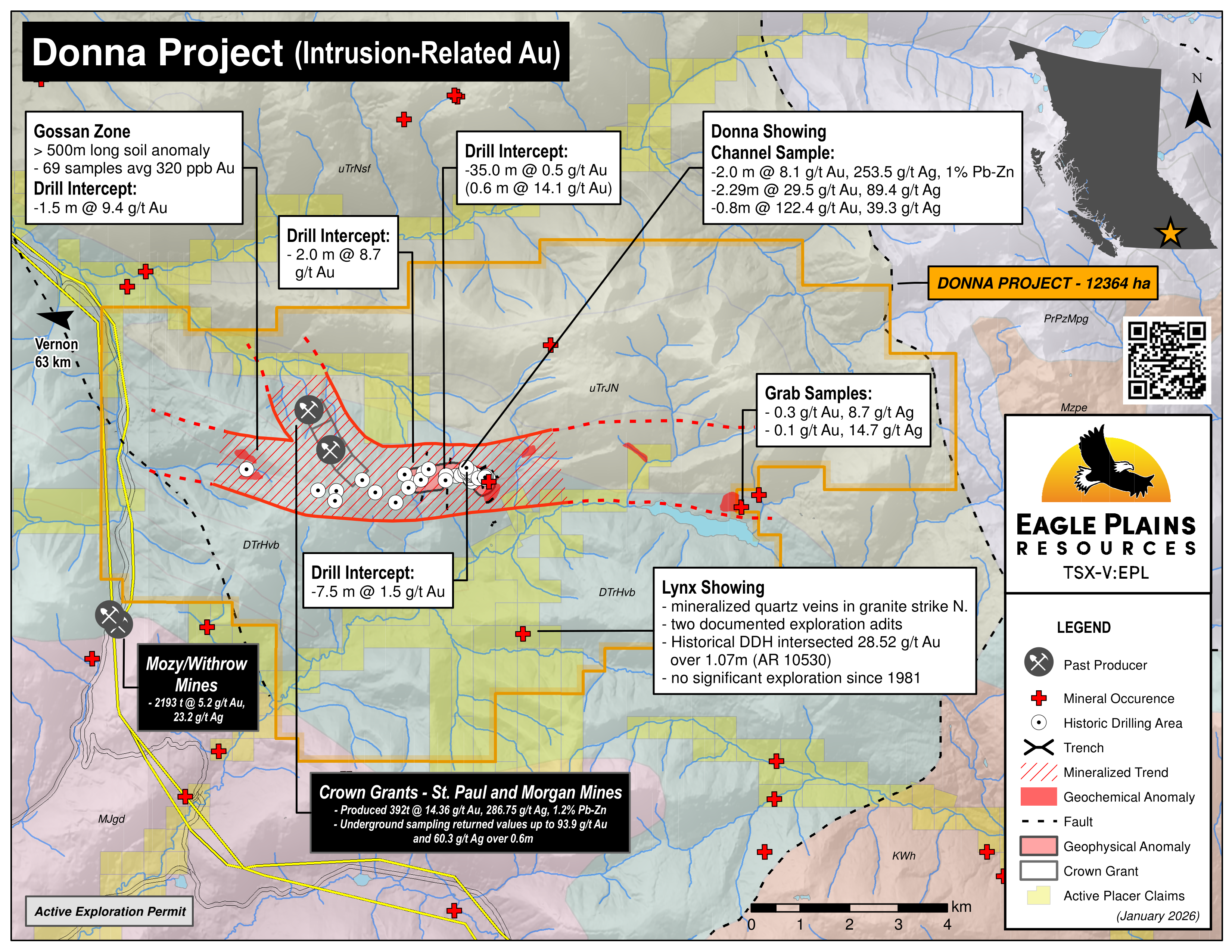
The Donna Property is located in south central British Columbia approximately 63 km east of Vernon and is accessed by a network of well-maintained logging roads. The 12,364 ha project was acquired in 2016 by way of agreement with ALX Uranium Corp. and is 100% controlled by Eagle Plains with an underlying 2% NSR. In 2020, 4 crown grants that are host to the past producing St. Paul and Morgan mines were added to the property.
-
- British Columbia
-
- Available for option: Yes
-
- Gold,
- Silver,
- Copper,
- Molybdenum
Project Highlights
- Underexplored intrusion-related gold targets with drill results of 2.0m @ 8.7 g/t Au
- Encouraging exploration to date including mineralized drill intercepts
- Numerous mineralized occurrences potentially related to a larger system
- Untested high-priority targets with coincident geochemical and geophysical anomalies
- Excellent infrastructure – road-accessible, nearby hydro, railhead within 50 km, 97 km to Vernon
Summary
Geology
The Property is underlain by a sequence of marine sediments comprising carbonaceous black argillite, limestone, and volcanic rocks of an unassigned unit of Permian – Lower Triassic age. The Dona showing lies within a sill-like diorite plug which intrudes NW trending, interbedded limy argillite and tuffs. It is partially conformable with the enclosing metasedimentary rocks. Fine-grained biotite-rich diorite commonly occurs as narrow dykes cutting both sedimentary rocks and hornblende diorite. Small equigranular, medium grained granite dykes have been recognized to the west of the hornblende diorite body. The age of these intrusive rocks and their relationship, if any, to the mapped Spruce Grove Batholith to the south is unknown.
History
The Dona Showing was discovered in 1973 by the El Paso Mining and Milling Company. Geochemical and geophysical surveys outlined a multi-element soil anomaly (As–Au-Ag-Pb) over 800m varying 60m to 180m in width.
Between 1974 and 2014, 16 separate exploration programs were conducted on the property by various operators. These programs included ~ 2500m of trenching, 2 test pits, heavy mineral sampling, mapping and prospecting, 7 grid soil surveys, bio-geochemical surveys, several ground-based geophysical surveys and 4 diamond drill programs totalling greater than 3300m over 40 holes.
In 2016 Eagle Plains acquired the property by way of agreement with ALX Uranium Corp, previously ESO Uranium Corp. The property has undergone a compilation of existing data and a field program was carried out during the 2017 field season.
Eagle Plains Exploration
In June 2017 an airborne magnetic geophysical survey was flown over the southern portion of the property
In October soil geochemical surveys were conducted to expand coverage and confirm historic anomalies in three areas:
- North of Keefer Lake
- North of the Dona occurrence and was partially guided by geophysics
- Infill coverage in the newly acquired western area of the property that had been identified as prospective through the data compilation process
The 2017 program identified prospects geologically similar both east and west of the Dona Showing over 8km and are considered to potentially represent the surface expression of a much larger hydrothermal system.
In October 2019, optionee Pinnacle North, conducted a single drill-hole to a depth of 331.2m. The hole, not completed to target depth due to budgetary constraints, intercected 9.41 g/t gold over 1.5m from 134.0-135.0m
Future Work
In July 2020, Eagle Plains purchased 4 crown grants located in the NW portion of the property containing the St. Paul and Morgan mines. Recommendations from the last program to be carried out on these grants was for detailed mapping of gold-bearing quartz veins and trenching of the Morgan showing, followed by a small diamond drilling program. A magnetometer survey of the St. Paul area was also recommended to locate drill targets along the diorite contacts. No historical drilling activity has been reported on the St Paul/Morgan property. Eagle Plains plans to review technical data associated with these crown grants and assess within the geological context of the overall Donna property holdings. Should results warrant, Eagle Plains intends to carry out additional diamond drilling activity.
Future work programs will guided by exploring the potential of a large hydrothermal system in the area of the geologically similar mineralized showings located over 8km both east and west of the Dona Showing. It is recommended that these programs consist of:
- Detailed geochemical and geophysical surveys in the western portion of the property to follow up the Au anomaly located as a result of the 2017 field work.
- Ground based geophysical surveys north of Keefer Lake
- Diamond drilling to test defined targets
Eagle Plains - A Project Generator
Eagle Plains Resources is a project generator with several mineral exploration properties of merit that meet qualifying transaction requirements. We facilitate the listing process for capital pool companies and initial public offerings while providing technical expertise for exploration programs. Companies interested in co-operatively exploring any of our projects please contact: Chuck Downie at ccd@eagleplains.com or Andrew Wilson at abw@eagleplains.com or call 1 866 Hunt Ore (486 8673).
Details
The Donna Property is located in south central British Columbia approximately 63 km east of Vernon and is accessed by a network of well-maintained logging roads. The 12,364 ha project was acquired in 2016 by way of agreement with ALX Uranium Corp. and is 100% controlled by Eagle Plains with an underlying 2% NSR. In July 2020, Eagle Plains added significantly to the gold exploration potential of the property by purchasing 4 crown grants located in the NW portion of the property that are host to the past producing St. Paul and Morgan mines. No historical drilling activity has been reported on the St Paul/Morgan property.
Donna Project Geological Model
Project Highlights
- Underexplored intrusion-related gold targets with drill results of 2.0m @ 8.7 g/t Au
- Encouraging exploration to date including mineralized drill intercepts
- Numerous mineralized occurrences potentially related to a larger system
- Untested high-priority targets with coincident geochemical and geophysical anomalies
- Excellent infrastructure – road-accessible, nearby hydro, railhead within 50 km, 97 km to Vernon
Geology
The Property is underlain by a sequence of marine sediments comprising carbonaceous black argillite, limestone, and volcanic rocks of an unassigned unit of Permian – Lower Triassic age. The Dona showing lies within a sill-like diorite plug which intrudes NW trending, interbedded limy argillite and tuffs. The diorite is fine- to medium-grained, equigranular and forms a NW striking elongate pluton. It is partially conformable with the enclosing metasedimentary rocks. Fine-grained biotite-rich diorite commonly occurs as narrow dykes cutting both sedimentary rocks and hornblende diorite. Small equigranular, medium grained granite dykes have been recognized to the west of the hornblende diorite body. The age of these intrusive rocks and their relationship, if any, to the mapped Spruce Grove Batholith to the south is unknown.
History
The Monashee Mountains were first explored during the 1870s, when placer gold was discovered in Cherry Creek and in the upper parts of the Kettle River.
Many lode gold showings were subsequently discovered but it wasn’t until 1973 that the Dona showing was discovered by El Paso Mining and Milling Company which had conducted a regional stream sediment sampling program indicating anomalous values of gold and arsenic in local streams. The program was expanded and rock and soil sampling along with an electromagnetic geophysical survey outlined a multi-element soil anomaly (As–Au-Ag-Pb) over 800m varying 60m to 180m in width.
In 1974, El Paso completed 13 trenches totalling 1915m, two test pits and 980m drilling over 19 holes. Trenching exposed numerous narrow quartz veins, with assays of 29.5 g/t Au and 89.4 g/t Ag over 2.29m and 122.4 g/t Au and 39.3 g/t Ag over 0.8m in two separate trenches. Gold and silver grades were lower in the drill program than observed in the trenches, likely due to poor recovery methods.
In 1981, Brican Resources carried out a heavy mineral stream survey in the area of Monashee Mountain.
In 1982, reconnaissance soil sampling was carried out followed by grid soil surveys. Anomalous gold and arsenic were reported. Granex enlarged the property and resampled parts of the historical trenches. Ten mineralized quartz zones were identified and appeared to be associated with altered crystal tuffs and debris flows.
In 1983, soil sampling and mapping 2 km west of the property delineated a sill-like feldspar-quartz porphyry with an associated 500 m long gold and arsenic soil anomaly. Anomalous gold values occur in the more altered (sericite and calcite), quartz and pyrite-rich rocks.
In 1988 Keefer Resources tested beyond the historic trenches by conducting prospecting and geological mapping along with a limited stream sediment geochemical survey. Follow up work consisted of two soil grids. Although only spot gold anomalies were outlined, a number of silt stream sediment samples were anomalous along the Kettle River and tributaries.
In 1992, Phelps Dodge optioned the property and conducted gridded soil surveys and excavated 4 additional trenches resulting in outlining a gold-silver-arsenic soil anomaly of 1,600m long by up to 300m, extending south of the historic trenches.
From 1992 to 1994, Cameco Corporation completed geological mapping, and geochemical and geophysical surveys with part of the work falling within the current Property boundary.
In 1996 Carbon Reef Resources completed a 177m drill program over 3 holes in historic trenches 4 and 5. Best intersection was 10.1 g/t Au and 6.2 g/t Ag over 0.6m.
From 1999 to 2001, Jones, one of the owners of the property, carried out bio-geochemical surveys.
In 2009, ESO Uranium conducted reconnaissance stream sediment and rock geochemical surveys, focussing on an area west of the 1992 Phelps Dodge grid. In 2010 a detailed grid soil survey outlined a patchy NW trending gold anomaly over 950m by 350m area with partially coincident silver, arsenic, lead, antimony and nickel soil anomalies. This was followed by a seven hole, 850 m diamond drill program.
In 2011, a 13 hole, 1,633 m drill program intersected gold and silver mineralization across several metres within carbonate-rich skarn and altered diorite. Highest grades were found within sulphide rich quartz veins with carbonate selvages. It was concluded that gold and silver mineralization continued along the downdip extension west of the historic trenches.
In 2014 Alpha Exploration conducted a 4 hole, 492m drill program west of the area of historical trenching. Holes were targeted using chargeability highs and structures outlined in the IP geophysical survey. Results ranged from trace concentrations to a high of 8.72 g/t gold over 2.0m.
In 2016 Eagle Plains acquired the property by way of agreement with ALX Uranium Corp. The property has undergone a compilation of existing data and a follow up field program was conducted during the 2017 field season.
July 2020, Eagle Plains acquires 4 crown grants internal to the property and located in the NW portion. These crown grants are host to the St. Paul and Morgan mines that for the period 1914-1961 produced a total of 392 tonnes containing 5,630 grams of gold, 112,406 grams of silver, 3,720 kilograms of lead and 1,258 kilograms of zinc. Reports and government publications report underground sampling returning values ranging from trace quantities to highs of up to 93.9 g/t (2.74 oz/t) gold and 60.3 g/t (1.76 oz/t) silver over a 0.6m sample width.
Eagle Plains Exploration
In June 2017 an airborne magnetic geophysical survey was flown over the southern portion of the property
A field program was carried out in October consisting of soil geochemical surveys to expand coverage and confirm historic anomalies in three areas:
- North of Keefer Lake
- North of the Dona occurrence and was partially guided by geophysics
- Infill coverage in the newly acquired western area of the property that had been identified as prospective through the data compilation process
The 2017 program identified prospects geologically similar both east and west of the Dona Showing over 8km and are considered to potentially represent the surface expression of a much larger hydrothermal system.
Future Work
In July 2020, Eagle Plains purchased 4 crown grants located in the NW portion of the property containing the St. Paul and Morgan mines. Recommendations from the last program to be carried out on these grants was for detailed mapping of gold-bearing quartz veins and trenching of the Morgan showing, followed by a small diamond drilling program. A magnetometer survey of the St. Paul area was also recommended to locate drill targets along the diorite contacts. No historical drilling activity has been reported on the St Paul/Morgan property. Eagle Plains plans to review technical data associated with these crown grants and assess within the geological context of the overall Donna property holdings. Should results warrant, Eagle Plains intends to carry out additional diamond drilling activity.
Future work programs will guided by exploring the potential of a large hydrothermal system in the area of the geologically similar mineralized showings located over 8km both east and west of the Dona Showing. It is recommended that these programs consist of:
- Detailed geochemical and geophysical surveys in the western portion of the property to follow up the Au anomaly located as a result of the 2017 field work.
- Ground based geophysical surveys north of Keefer Lake
- Diamond drilling to test defined targets
Eagle Plains - A Project Generator
Eagle Plains Resources is a project generator with several mineral exploration properties of merit that meet qualifying transaction requirements. We facilitate the listing process for capital pool companies and initial public offerings while providing technical expertise for exploration programs. Companies interested in co-operatively exploring any of our projects please contact: Chuck Downie at ccd@eagleplains.com or Andrew Wilson at abw@eagleplains.com or call 1 866 Hunt Ore (486 8673).
Updated March 19, 2026

Eagle Plains/Annacotty Resources Announce 2023 Field Program at the Donna Gold Property, South-central, BC

Eagle Plains/Annacotty Resources Execute Option Agreement on Donna Gold Property, South-central, BC
Eagle Plains Announces Drill Results From 100% Owned Donna Project, South-Central British Columbia
Eagle Plains Commences Geophysical Survey at Schott’s Lake Copper Project
Photos