Black Diamond Project
The 866 ha Black Diamond Property is located near Invermere, B.C. and covers a deep-seated mineralized structure traced over 12 km hosting high-grade Au, Ag, Pb and Zn vein mineralization. It has significant potential to host classic manto- or replacement-style ore bodies and contains multiple mineral occurrences that appear to be linked by a common structure. The project is 100% owned by Eagle Plains with a 2% NSR held by Summit Royalties containing a 1% buy-back clause.
-
- British Columbia
-
- Available for option: Yes
-
- Silver,
- Gold,
- Copper,
- Zinc,
- Lead,
- Antimony
Project Highlights
- Numerous polymetallic high-grade showings focussed along a major structure
- Encouraging exploration to date including multiple high-grade drill intercepts
- Excellent infrastructure – road-accessible with nearby hydro and rail
- Historical past-producer
- Adjacent the Mineral King which produced 1,334,400 t @ 11% Zn-Pb
Summary
The 866 ha Black Diamond Property is located near Invermere, B.C. and covers a deep-seated mineralized structure that has been traced over 12 km hosting high-grade Au, Ag, Pb and Zn vein mineralization. It has significant potential to host classic manto- or replacement-style ore bodies and contains multiple mineral occurrences that appear to be linked by a common structure. The project is 100% owned by Eagle Plains with a 2% NSR held by Summit Royalties containing a 1% buy-back clause
Project Highlights
- Numerous polymetallic high-grade showings focussed along a major structure
- Encouraging exploration to date including multiple high-grade drill intercepts
- Excellent infrastructure – road-accessible with nearby hydro and rail
- Historical past-producer
- Adjacent the Mineral King which produced 1,334,400 t @ 11% Zn-Pb
Geology
The N-S trending Black Diamond structure strikes 12km with a near-vertical dip exposed vertically up to 1 km. Multi-phase silica emplacement suggests the presence of a large pre-existing structure which became the locus for later mineralization.
Exploration History
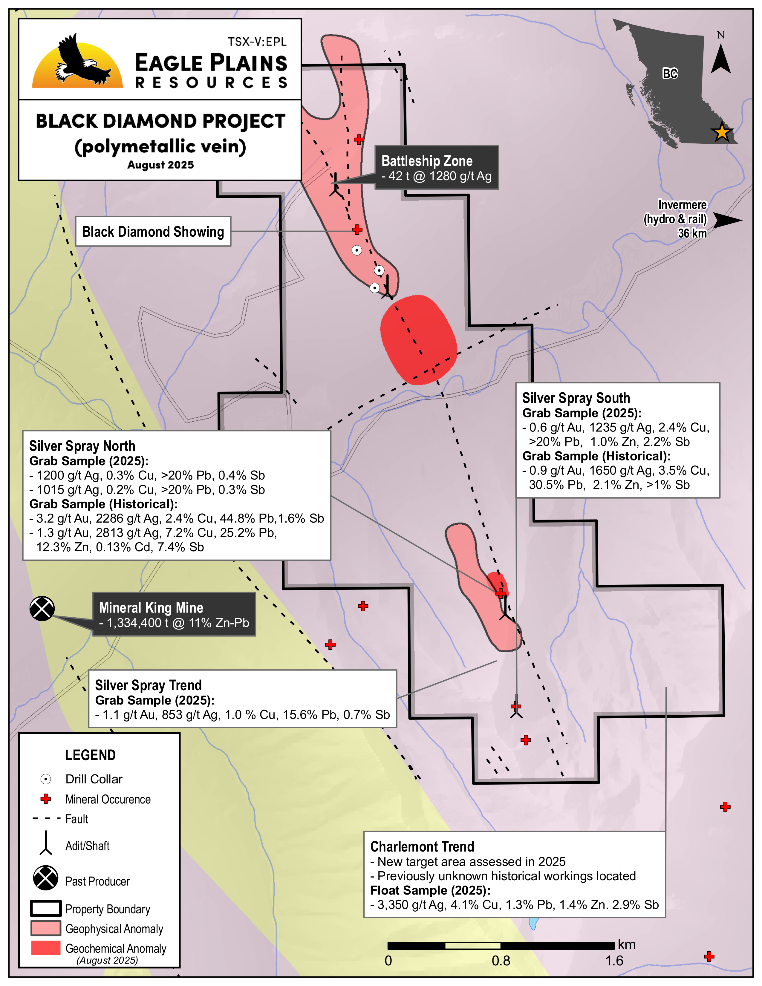
Historical workings from the late 1800s exists in several areas along the structure, production included 42 t @ 1280 g/t Ag from the Battleship Zone
1995 exploration program included drilling of the Black Diamond vein at the Battleship Zone, results include:
| Sample Type | Results | Sample Location |
|---|---|---|
| 3 m drill intercept | 93.7 g/t Ag, 9.66% Pb, 5.22% Zn | Battleship Zone |
| 1 m drill intercept | 136.8 g/t Ag, 4.56% Pb, 0.29% Zn | Battleship Zone |
| 24 m channel sample | 746 g/t Ag, 25% Pb and 5% Zn | Exposed vein material in an adit |
Exploration from 2004 to 2006 included airborne geophysics which defined the Black Diamond Structure and another NE trending structure. Geological mapping defines stratigraphy.
In 2012, drilling further tested the Black Diamond Structure, results include:
| Sample Type | Results | Sample Location |
|---|---|---|
| 1.58 m drill intercept starting at 170m | 4.3% Pb, 5.1% Zn and 111g/t Ag | Battleship Zone |
| 9.8 m drill intercept starting at 164m | 3.98% Pb/Zn, 49.3 g/t Ag | Battleship Zone |
Project Zones
The property contains 2 zones where high-grade silver occurrences have been discovered, explored and mined. High-grade silver exceeding 1200 g/t and up to 4200 g/t, gold from 3.2 g/t and lead up to 44% is found in these zones. Mineralization is found both in veins hosted in dolomite and quartz carbonate veins, significant values of zinc and copper are also associated. Geochemical and geophysical surveys including mapping have defined the location of mineralized structures.
Future Work
Defining structural controls for high-grade Ag and Au mineralization
Geochemical sampling, mapping and prospecting along the Black Diamond fault to locate new mineralization and identify structural traps for ore-bearing fluids
Data compilation to identify drill targets along the main structure and near mineral occurrences
Eagle Plains - A Project Generator
Eagle Plains Resources is a project generator with several mineral exploration properties of merit that meet qualifying transaction requirements. We facilitate the listing process for capital pool companies and initial public offerings while providing technical expertise for exploration programs. Companies interested in co-operatively exploring any of our projects please contact: Chuck Downie at ccd@eagleplains.com or Andrew Wilson at abw@eagleplains.com or call 1 866 Hunt Ore (486 8673).
Details
The Black Diamond Property is located in the Purcell Mountains 35 km west-southwest of the community of Invermere, B.C., 5 km east of the historical Mineral King Mine.
The 866 ha property covers approximately 6km of a prominent mineralized structure that has been traced over 12 km with vertical continuity of over 1,000 m and hosts high-grade silver, lead and zinc vein mineralization, with gold values up to 3.2 g/t. The property also has significant potential to host classic manto- or replacement-style ore bodies similar to the nearby Mineral King Mine. The Black Diamond boasts multiple mineral occurrences which appear to be linked by a common structure.
The project is 100% owned by Eagle Plains with a 2% NSR held by Summit Royalties containing a 1% buy-back clause. Access is by all-weather road with a network of logging and historical roads and trails providing additional access to the individual mineral showings.
Project Highlights
- Numerous polymetallic high-grade showings focussed along a major deep-seated structure
- Encouraging exploration to date including multiple high-grade drill intercepts
- Excellent infrastructure – road-accessible with nearby hydro and rail
- Historical past-producer
- Adjacent the Mineral King which produced 1,334,400 t @11% Zn-Pb
Geology
The claims cover a mineralized system hosted by the Dutch Creek Formation of the Proterozoic Purcell Supergroup. The Black Diamond Structure is exposed within the Delphine, Toby and Copper Crown Drainages, exhibiting a NNW/SSE strike over 12 km and near-vertical dip. The structure shows evidence of multi-phase silica emplacement suggesting the presence of a large pre-existing structure which became the locus for later mineralization.
History
Between 1954 and 1967 the nearby Mineral King Mine produced a total of 1,334,400 tons of ore grading 8% Zn and 3% Pb. Other significant historical workings dating back to the late 1800s exist in three areas along the Black Diamond Structure and consist of tunnels, pits and trenches. These areas are Black Diamond and Silver Spray zones. Highlights from individual workings in these zones are as follows:
Black Diamond Zones
Battleship Zone
Seven adits were driven into the main Black Diamond Structure in the area of the Battleship Zone over an elevation of approximately 570 m. Development at the Battleship Zone itself, an 8 m wide mineralized quartz occurrence, included two small tunnels, a raise and several open cuts. The Battleship Zone was the focus of the Eagle Plains drill program in 1995, see results below.
| Sample Type | Results | Sample Description |
|---|---|---|
| Bulk Sample | 42 t @ 1280 g/t Ag | Mined from the Black Diamond Vein 1906-07 |
| Drill | 3m @ 93.7 g/t Ag, 9.6% Pb, 5.2% Zn | 28m depth - 1995 EPL drilling |
| Drill | 1m @ 136.8 g/t Ag, 4.5% Pb, 0.29% Zn | 20m depth - 1995 EPL drilling |
| Drill | 2.83m @ 4.3% Pb, 5.1% Zn, 111 g/t Ag | True thickness 1.58m, starting at 170m - 2012 EPL drilling |
| Drill | 9.8m @ 3.98% Pb/Zn, 49.3 g/t Ag | Entire mineralized interval, starting at 164m - 2012 EPL drilling |
| Channel | 24m @ 746 g/t Ag, 25% Pb, 5% Zn including 6m @ 1445 g/t Ag | Exposed vein material in adit |
Silver Spray Zone
At the Silver Spray, galena, tetrahedrite, cerussite, sphalerite and copper carbonates occur in a series of vertical, bedding-parallel veins up to 20 cm width. Historical workings include 2 adits approximately 1 km apart.
| Sample Type | Results | Sample Location |
|---|---|---|
| Grab | 1.3 g/t Au, 2813 g/t Ag, 7.2% Cu, 25.2% Pb, 12.3% Zn, 0.13% Cd, 7.4% Sb | Vein material from north adit |
| Grab | 3.2 g/t Au, 2286 g/t Ag, 2.4% Cu, 44.8% Pb, 1.6% Sb | Vein material from north adit |
| Grab | 0.9 g/t Au, 1650 g/t Ag, 3.5% Cu, 30.5% Pb, 2.1% Zn, >1% Sb | Vein material from south adit |
Eagle Plains Exploration
In 1995, a 4-hole - 180 m drill program was conducted along the Black Diamond Vein in the Battleship Quartz Zone. Exploration results above.
In 2004 the area was covered by an airborne geophysical survey which successfully imaged the trace of the Black Diamond Structure, as well as a NE-trending structure.
The 2006 exploration program included prospecting and mapping along the Black Diamond Structure, on the north side of Toby Creek . Mapping defined relatively simple stratigraphy with phyllitic dolomitic siltstone dominant in the valley bottom, transitioning upwards into thicker bedded dolomite at the mid-level workings from 1800 to 2000 m, and finally upwards into quartz rich phyllitic siltstone and massive quartzite exposed in the upper working at around the 2250 m elevation. The mapping was also successful as a first pass ground-truthing of the 2004 airborne geophysical survey.
Compilation of the 2006, 2004 and 1995 data has allowed a refinement of the location of the Black Diamond mineralized structure and can tentatively be used to interpret a NNW trending anticline/syncline couplet with wavelength of approximately 350 m. Relationships between the Black Diamond Fault and folding remain uncertain.
2012 Field Program
In June 2012, a 2 hole - 400m drill program was carried out to further test the Black Diamond Structure. Exploration results above.
Subsequent to the 2012 drill program a field program was conducted to assess the Silver Spray Zone and the trace of the Black Diamond Structure.
Future Work
Silt and soil sampling, mapping and prospecting along the inferred trace of the Black Diamond fault zone to locate new mineralization and identify potential structural traps for ore-bearing fluids
Comprehensive data compilation to identify targets for diamond-drill testing of both the main structure and historic mineral occurrences
At the Black Diamond Property a number of high-grade precious- and base-metal showings appear to be related to a common district-scale structure. The current Eagle Plains tenure holdings consolidate many of these occurrences.
Eagle Plains - A Project Generator
Eagle Plains Resources is a project generator with several mineral exploration properties of merit that meet qualifying transaction requirements. We facilitate the listing process for capital pool companies and initial public offerings while providing technical expertise for exploration programs. Companies interested in co-operatively exploring any of our projects please contact: Chuck Downie at ccd@eagleplains.com or Andrew Wilson at abw@eagleplains.com or call 1 866 Hunt Ore (486 8673).
Updated March 19, 2026

Eagle Plains Reports 2025 Results at Black Diamond Antimony and Precious Metal Project and Applies for Additional Tenure

Fieldwork Commences on Eagle Plains’ Black Diamond Antimony and Precious Metal Project

Eagle Plains Mobilizes Crews for 2025 Field Season
Eagle Plains Announces Drill Results from Black Diamond Project, South-eastern British Columbia
Photos